Smart phones are of great help when taking transit, offering specific transit apps, gps, internet access… However, despite the seemingly ubiquity and practicality of smart phones for such trips it is difficult to replace the accessibility and simplicity of well-designed transit maps. Recently The Atlantic Cities took a look a couple of ‘fantasy transit maps‘ created by Brian Stokle that show “how a single, unified transit map might provide greater accessibility and ease of use” with hopes to “stimulate conversation about how transit decisions are made”.
Stokle used five criteria in determining how to create his easy to read, unified maps of Bay Area transit, including:
Focus on the customer’s needs, especially those who are new to transit (new commuters, tourists, visitors, etc.) and for locals unfamiliar with how to get to a certain part of the Bay Area.
and
Show only frequent, fast, and reliable transit, principally rail transit. Rapid bus routes were also included because they are fast and frequent as well. Some other transit was shown for reference (e.g. peak period commuter rail, trunk bus lines where no rapid transit exists) but showing every bus line would have been too confusing and unhelpful.
See below Stokle’s map of all current, and under construction projects that meet his criteria.
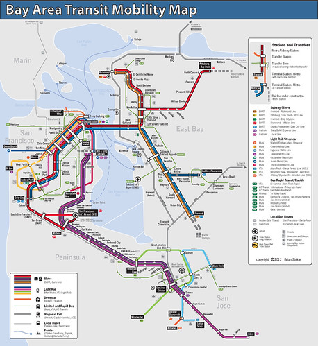
Credit: Brian Stokle
The article is an interesting read, contemplating how to strike the most user-friendly balance between schematic and geographic mapping and proceeding to share what a unified transit map of all existing, planned (but may lack commitment, funding) and some additional suggested lines that meet Stokle’s five criteria may look like. Hop over to The Atlantic Cities and give the article a read.