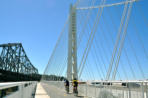
(Two people enjoying the toll-free, bicycle-pedestrian path along the new Bay Bridge span. Photo credit: Sharon Hahn Darlin)
The bicycle and pedestrian path along the new East Bay span of the Bay Bridge has proved incredibly popular, even though one still can’t completely reach San Francisco by bicycle or foot. People just really like recreating outdoors, enjoying breath-taking views in one of the most beautiful parts of California– who knew?
Have yet to go for a walk or ride? Enjoy a virtual tour of ascending and descending the bicycle-pedestrian path by bike, courtesy of KQED SCIENCE:
(Ascending. Video credit: KQED SCIENCE)
(Descending. Video credit: KQED SCIENCE)
Once completed all the way to San Francisco, popularity of the bicycle-pedestrian path will surely soar, for both commuting and recreational purposes. However, until then, the completed East Bay span still provides some unique and fantastic views worth seeing. If you’d like to check out the new path, be sure to get details about how to access the path (helpful map included) and its winter hours from the bridge’s website.
Tag: Bay Bridge Bicycle Pathway
Bay Bridge Update
 Let’s check in on the Bay Bridge bike and pedestrian path, shall we?
After the Loma Prieta earthquake destroyed a section of the Bay Bridge in 1989, Caltrans began pursuing ways to improve the bridge, not just repair it. Now 22 years later, the eastern portion of the bridge is on schedule to open in 2013.
The new eastern span will open with a 15.5 foot-wide bicycle and pedestrian path. The new path will run along the eastbound (south) deck. Bicycling enthusiasts are celebrating the span already, especially as the deck emerges in the ongoing construction. Can you wait to bike to Treasure Island on this?

Not to disparage Treasure Island, but why not go all the way to San Francisco? Especially as the few remaining gaps in the Bay Trail are filled, bicyclists are demanding (and getting) safe and extensive regional corridors access. Caltrans and the Metropolitan Transportation Commission agree, and released a feasibility study for a bike/ped path on the western span of the bridge in 2001.
On the western span, pathways would cantilever off either side of the bridge. These pathways are being designed to serve multiple functions, such as a place for maintenance crews and emergency vehicles (reducing the need to close traffic lanes).

Plus, imagine the view.
Other Bay Bridge Trivia:
- When the eastern portion of the bridge opens, the 1.2 mile section from Yerba Buena Island to Oakland will be the longest span supported by a single tower. Most suspension bridges have two or more towers.
- The fourth piece of the tower was addd earlier this month, and the fifth and final piece should go into place in April.
- The final tower will be 525 feet above the water.
- The tower and suspension cables will create an asymmetrical profile.
- The new span will also feature side-by-side decks, instead of the current double-decked structure.
- The full bike route:

Pictures are from the SF Citizen and SF Bike Coalition.
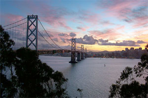
West Span Bay Bridge Bicycle and Pedestrian Pathway Moves Closer to Reality

Good news for those hoping to make the journey from Yerba Buena Island to San Francisco by foot or bicycle! Plans for a bicycle and pedestrian pathway across the western span of the Bay Bridge may be one step closer towards fruition.
The state Assembly Committee on Transportation passed Senate Bill 1061, which would allow a portion of Bay Bridge toll funds to be spent on the project, yesterday afternoon. The bill passed the Senate on June 1 and will now go to the state Assembly Committee on Appropriations to determine whether the Bay Area Toll Authority should be permitted to use toll funds on construction of the pathway. If the bill passes, the pathway will open in 4 years.
The largest hindrance to the bill is cost- the original cost was estimated to be between $168 and $350 million 10 years ago and a new estimate will not be available until spring 2011. Additionally, toll funds are restricted due to safety costs.
MacDonalds Architects have proposed a design for the pathway, which would provide a “unique means for [pedestrians and cyclists] crossing the bay.” The plans include a plaza for visitor congregation, lampposts in place every 60 feet, and accessibility points for wheelchairs, bicycles, pedestrians, and maintenance vehicles.
Image by macinate