The public is invited to a community workshop being hosted by supervisors Karen Mitchoff and Candace Andersen tomorrow, June 2, to share potential transportation safety and congestion relief projects related to the Central County Area of Benefit (Central Contra Costa County). Staff from Contra Costa Public Works will provide updates on intersection improvements, traffic calming measures, bicycle lanes and walkable shoulders.
Come prepared to share your ideas.
When: Tuesday June 2, 7-9 p.m.
Where: Downtown Walnut Creek Library, Oak View Room, 1644 N. Broadway, Walnut Creek
Tag: traffic calming
DIY Traffic Counting Device Brings Transportation Planning to Public
Note: TrafficCOM is now known as WayCount.
Are you curious to know how weather affects the number of people that use the new bike lane in the neighborhood? Or how traffic patterns change during summer break? Anecdotal observations are useful in finding the answer to these questions but sometimes nothing compares to having data at hand.Getting the data just got a little easier with the arrival of TrafficCOM – a device available to the public that counts and monitors the speed and rate of traffic.
This is of course not a groundbreaking device, similar devices have existed for years but TrafficCOM is special because it is accessible and simple to use.
According to TrafficCOM’s website at only $140, the product costs about 1/10th the price of the least expensive comparable product. TrafficCOM also allows users to seamlessly upload and map their latest traffic count data and make it instantly available to anyone online.
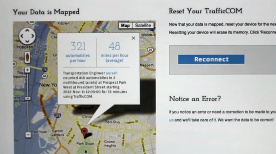
Uploading and mapping 78 minutes worth of data from counting northbound automobile traffic. Screen grab via: TrafficCOM
With this device residents can collect traffic data and share it with city staff much like SeeClick Fix, which relies upon the public to point out public works issues so local staff can be made aware of issues and resolve them in a timely manner.
A word of caution though, you may want to check with your local city planning or traffic engineering department prior to laying down the cord across the road!

TrafficCOM in action, counting bicycle traffic on a new bidirectional bike path in New York City. Screen grab via: TrafficCOM
Paris Bans Cars to Reduce Traffic
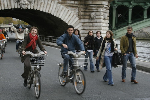
People on bikes on car-free Seine. Photo credit: William Lee-Wright
Mayor of Paris, France, Bertrand Delanoe wants his city to live up to its reputation as a relaxed, picturesque oasis but there’s only one problem– there’s too much traffic. So what’s the course of action to change this? Heavily restricted car use.
Al Jazeera’s Rory Challands reported the city’s bold action, noting Paris is perhaps more car crazy than one thinks when imagining people enjoying sidewalk dining on a pedestrian friendly Parisian boulevard:
Modern cities have becomes slaves to the automobile and Paris is no exception. Traffic jams, internal combustion engine and the car horn are as ubiquitous in Paris as they are anywhere. But change is afoot; the petrol powered dreams of the past are choking on their own noxious fumes and a newer, greener, more pedestrian friendly future is being attempted.
The decision to ban cars is part of a greater effort to encourage walking and cycling and make the banks of the Seine River a desirable spot in the city. Mayor Delanoe states simply:
It doesn’t make any sense that for several decades the banks of de Seine have been inaccessible to pedestrians.
Unlike North America cities, Paris, and much of Europe, was developed long before the advent of the automobile and so Delanoe wants to restore lost pedestrian access and reverse decisions in the 1960’s that made the city more car friendly at the expense of travel by foot.
Blast from the past: proposed conveyor belt transit for NY in 1954
In recent years New York City has been experimenting with innovative transportation solutions to a notorious traffic problem. The city has been creating bike lanes, bus lanes and pedestrian plazas from space formerly used to accommodate private motor vehicle traffic. The most famous of these changes has been the transformation of Times Square from a traffic choked intersection to a vast pedestrian plaza in 2009.
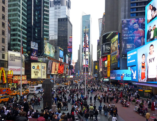
The Times Square plaza. (Photo credit: Payton Chung)
However, transportation innovations are not new to the Big Apple. Moving people has always been a major issue for New York City, but of all proposed transportation solutions, one the sticks out from the rest.
In 1954 the idea of removing all wheeled traffic – buses, trucks, and cars – and converting 5th Avenue into a giant conveyor belt to move people along the Avenue was contemplated. The Gothamist recently covered this odd idea in an article titled What if 5th Avenue Had No Cars, But Conveyor Belt Transportation Instead?. The article beings:
What if parts of Manhattan didn’t have vehicular traffic, but instead conveyor-belt transportation? We’ve visited the idea of moving sidewalks as it was proposed in the late 1800s, but here’s a later proposal, from 1954, which would have eliminated all wheeled traffic (and thus “roaring motors and noxious fumes”) as well as “nervous pedestrians scurrying back and forth at dangerous intersections.”
The conveyor belts were supposed to “beautify the street, reduce noise and help shoppers”. Read the full story and see pictures of what these conveyor belts would look like over at The Gothamist.
Why are bike-friendly cities safer?
 Davis, California is the bike-friendly capital of California, if not the United States. Over 16 percent of people bike to work! Compare that to Richmond’s 0.2%, or even Berkeley’s 8.9%.
Surprisingly, bike-friendly Davis, California has one tenth the traffic fatalities you would except for a city its size.
This week, urban planning blog Planetizen looks at Davis’s success, and digs a little deeper.
Traditionally, there’s a “safety in numbers” theory about bike safety. Knowing there are fragile bikers around makes drivers pause and drive more carefully. But that creates a sort of “chicken and the egg” problem – how is a street ever safe enough to attract more bikes?
Planetizen invited the authors of a new study, Evidence on Why Bike-Friendly Cities Are Safety for All Road Users, to share their research. Norman Garrick and Wesley Marshall propose that the same changes to street design that make roads safer for bicyclists also make driving safer for drivers and walking safer for pedestrians.
Think about it. Do you decide where to bike because you know people will be there, or because you know it has a bike lane?
This doesn’t mean that cities with lots of bicyclists don’t have lots of fender benders, but the odds of dying in a bike accident are much lower. That’s because the car is often moving more slowly. Anecdotal evidence of this relationship has been enough to launch complete street and traffic calming campaigns all over the country.

Traffic calming is simple. If you make a road look like it’s supposed to be driven slowly, people will drive slowly. This isn’t just changing posted speeds; we’re talking narrow lanes and making other road users more visible (either with bike lanes or pedestrian bulb outs).
Cities should indeed strive for ‘safety in numbers’ but before they can get to that point, they need to create bicycle friendly streets that will make it comfortable enough for the average Jane and Joe to take up biking. It is this act of creating comfortable and complete biking networks that ultimately results in both making cities biking friendly and, at the same time, making biking friendly cities safer for all users.
Contra Costa County residents can use the 511 Bike Mapper to find bike-friendly streets in your neighborhood. Whether your driving on a designated bike-friendly street or not, consider slowing down just in case.