![]()
2018 is here, and with it some new laws for transit and vanpool commuter benefits, walking and driving.
Pre-Tax Commuter Benefit: If your employer offers a program where you can pay for transit or vanpool commuting expenses with pre-tax dollars, the monthly cap for that benefit has risen to $260 for 2018. The pre-tax cap for biking expenses remains at $20.
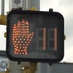 Pedestrian Crossing Signals (AB 390): For crosswalk signals which include a countdown timer, it is now legal for a pedestrian to enter the crosswalk after the countdown has started, as long as they can make it across by the time the counter reaches zero. It is still illegal to begin crossing at a traditional pedestrian signal (i.e. no countdown timer) after it has begun flashing.
Seat Belts on Buses (SB 20): Effective July 1, 2018 – In buses which are equipped with seatbelts, the law requires both the passengers and the driver to wear them. The driver is also responsible for informing passengers of this requirement.
Driving Passengers for Hire (AB 2687, 2016): Effective July 1, 2018 – Now lowered to match the current limit for bus and truck drivers, the blood-alcohol limit for individuals driving for Uber, Lyft and similar services has been lowered to 0.04 percent when carrying passengers.
New Fuel Taxes and Vehicle Fees(SB 1): A new ‘transportation improvement fee’ will be added to all vehicle registration fees – ranging from $25 to $175 based on the value of a car or truck.
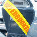 No Parking Citations at Broken Meters (AB 1625): You cannot be restricted from or ticketed for parking at a broken meter. However, you must still observe the posted time limit for parking.
Alcohol and Marijuana in Vehicles (SB 65, 94): Smoking or ingesting cannabis while driving or riding in a vehicle is prohibited. The law also prohibits the possession of an open container of cannabis or cannabis product when operating a motor vehicle.
To see the full text of any California law above, visit the California Legislative Information website.
Tag: pedestrian
I-680/Treat Blvd Bike/Ped Plan Workshop – Mon., May 22, 2017 (Walnut Creek)
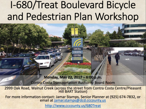
On Monday, May 22nd, Contra Costa County will host a community workshop on the I-680/Treat Boulevard Bicycle and Pedestrian Improvement Plan.
The goal is to identifiy improvements to serve bicyclists and pedestrians using the Treat Boulevard/I-680 corridor between the Iron Horse Trail, through the Interstate-680 (I-680) over-crossing near the Contra Costa Centre/Pleasant Hill BART station area, and extending west to Geary Road/North Main Street in the City of Walnut Creek.
Since the I-680/Treat Blvd overcrossing is one of the main arteries into the Contra Costa Centre/Pleasant Hill BART area from areas of Walnut Creek west of the freeway, residents and commuters are encouraged to attend this meeting and give feedback.
For more information contact: Jamar Stamps, Senior Planner at (925) 674-7832 or jamar.stamps@dcd.cccounty.us
To learn more about this project, please visit: http://www.cccounty.us/680Treat
North Concord to Antioch BART Access Study – Feedback Wanted (2017)
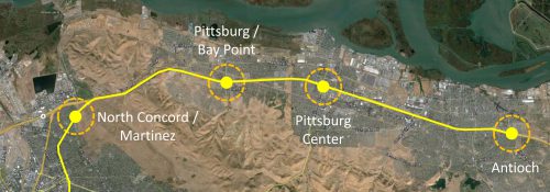
![]() Do you use the North Concord/Martinez or Pittsburg/Bay Point BART station? Live or work in East County? BART wants your input!
Do you use the North Concord/Martinez or Pittsburg/Bay Point BART station? Live or work in East County? BART wants your input!
With plans to expand East Contra Costa service in 2018, BART is conducting a study to identify projects to improve access to stations for pedestrians, bikes, vehicles and transit. They’ve drafted a preliminary document identifying barriers and proposing improvements, and now they want to hear from you!
For more information or to submit feedback, visit the North Concord to Antioch BART Study webpage.
Drive with Care: October is Walk to School Month (2016)
![]() International Walk to School Day is October 5. This means that in October, cities across the US (and throughout the world) will hold Walk to School events to encourage students and their families to get to school on foot and experience the benefits and joys of walking in their community.
International Walk to School Day is October 5. This means that in October, cities across the US (and throughout the world) will hold Walk to School events to encourage students and their families to get to school on foot and experience the benefits and joys of walking in their community.
 Schools in Antioch, Brentwood, Oakley, Concord, Pittsburg, Pleasant Hill and Walnut Creek will be teaming up with Street Smarts Diablo for Walk to School events. Events in Antioch, Concord, Pittsburg, Pleasant Hill and Walnut Creek will happen on October 5, while Brentwood and Oakley schools will celebrate on October 19.
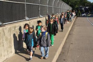 With more students walking to and from school with this national event, motorists are reminded to drive with extra care, stay alert for children crossing the road, and be especially aware of school zone speed limits.
For a list of participating schools and event dates, visit the Street Smarts Diablo website.
Share Our Trail – 2015 Trail Safety Campaign
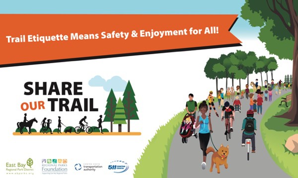
511CC is partnering with the East Bay Regional Park District (EBRPD) for a trail safety awareness campaign called Share Our Trail. The campaign is designed to increase awareness of bicycle and pedestrian safety on the mixed-use paved trails. Staff from 511CC and EBRPD will target busy sections along the Iron Horse, Contra Costa Canal and Lafayette-Moraga Trails from June through mid-September 2015.
Staff will be on the Iron Horse Trail at Love Lane, in Danville, July 15 from 7-9:30 a.m. and Saturday, July 18th from 9:30 a.m. – noon.
Look for campaign posters in the display boxes on the Iron Horse and Contra Costa Canal Trails this summer. For more information, email info@511contracosta.org.
Draft Walnut Creek Pedestrian Master Plan – Give Your Input! (2015)
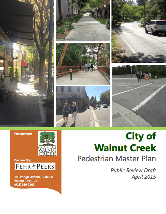
The Draft Walnut Creek Pedestrian Master Plan is now available for public review! The City of Walnut Creek wants your feedback and will be accepting public comments – via phone, online and at meetings – through Friday, June 12, 2015.
The Pedestrian Master Plan (PMP) is Walnut Creek’s first citywide planning effort focused on making walking safer, easier and more popular. The finished PMP will:
- Outline goals, policies and actions to guide the evolution of walking in the city.
- Assess existing conditions for walking.
- Develop broad recommendations for physical improvements.
- Recommend programs and activities to promote and encourage walking.
- Formulate guidelines for the design of sidewalks, crosswalks and footpaths.
Particular attention will be paid to improving access to schools, transit, open space areas, parks and neighborhood shopping centers, as well as within the Downtown area. The planning effort relies on the public’s involvement to help shape the PMP.
If you’re interested in attending a public meeting, there are opportunities on May 4, 6 & 28 at Walnut Creek City Hall. For details on meeting times and locations, to read the Draft PMP, or to give feedback, visit the City of Walnut Creek’s ‘How to Get Involved’ page.
Bike & Pedestrian Path Coming to Richmond-San Rafael Bridge (2015)
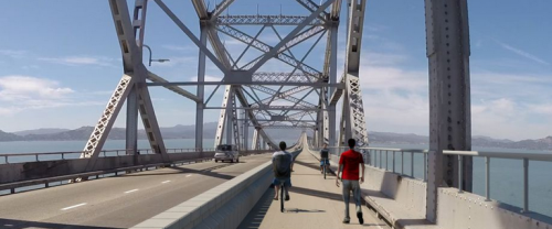
Plans are underway to build a separated bike/pedestrian path on the upper deck of the Richmond-San Rafael Bridge. As part of a four-year Metropolitan Transportation Authority (MTC) pilot project, the shoulders on the upper and lower decks of the bridge will be converted to a bike/pedestrian path and a traffic lane, respectively.
The bike/pedestrian path is slated to be 10 feet wide, separated from vehicles by either a movable barrier or temporary concrete walls, and include a raised approach on the bridge’s east side. In addition to the new path, transportation officials plan to build a bike/pedestrian trail connecting the bridge and Richmond to Point Molate.
If all goes according to plan, the bike/pedestrian path will be completed in the fall of 2017. Once complete, the new path will fill a major gap in the Bay Trail.
More information is available here.
Image courtesy Bay Area Toll Authority
Bike/Ped Path Coming to Richmond Bridge (2015)
Plans are underway to build a separated bike/pedestrian path on the upper deck of the Richmond-San Rafael Bridge. As part of a four-year Metropolitan Transportation Authority (MTC) pilot project, the shoulders on the upper and lower decks of the bridge will be converted to a bike/pedestrian path and a traffic lane, respectively.
The bike/pedestrian path is slated to be 10 feet wide, separated from vehicles by either a movable barrier or temporary concrete walls, and include a raised approach on the bridge’s east side. In addition to the new bridge path, transportation officials plan to build a bike/pedestrian trail connecting the bridge and Richmond to Point Molate.
If all goes according to plan, the bike/pedestrian path will be completed in the fall of 2017. Once complete, the new path will fill a major gap in the Bay Trail.
Concord's Bicycle & Pedestrian Master Plan Workshop – April 8, 2015
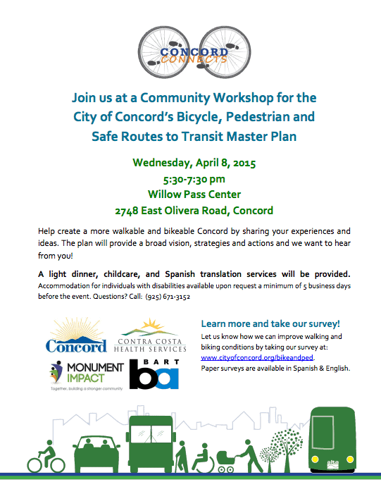 You’re invited to help create a more walkable and bikeable Concord at a Bicycle & Pedestrian Master Plan Community Workshop on Wednesday, April 8.
Community input is vital to the creation of the Bicycle & Pedestrian Master Plan, which seeks to improve access for pedestrians and bicyclists to the City’s BART stations, guide investments in infrastructure, improve connections between the regional trails network and downtown, and improve safe access between schools, jobs, downtown, and other important areas of the city.
A light dinner, childcare, and Spanish translation services will be provided.
Accommodation for individuals with disabilities is available by request a minimum of 5 business days before the event. For more information, view the event flyer or call (925) 671-3152.
To give immediate feedback on how Concord might improve walking and biking conditions, or to read more about the Bicycle & Pedestrian Master Plan, visit the City of Concord’s information page.
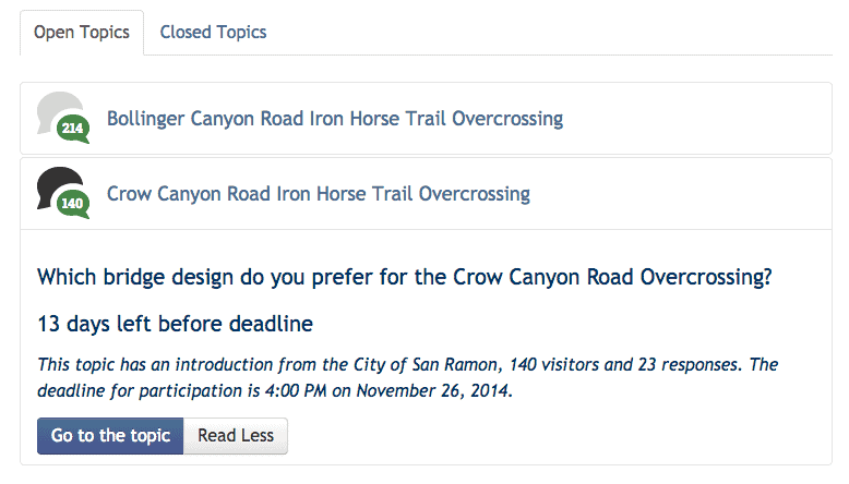
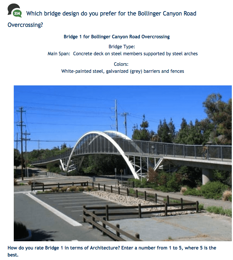
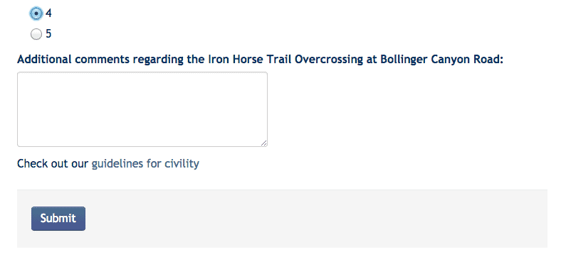
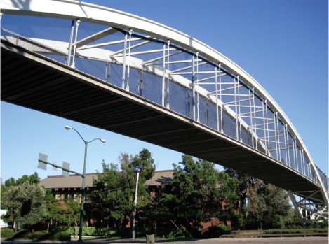
Iron Horse Trail Overcrossings – How to Give Your Design Input (2014)
The City of San Ramon is seeking community design input on proposed bicycle/pedestrian overcrossings along the Iron Horse Trail at Bollinger Canyon Road and Crow Canyon Road in San Ramon. The goal of the overcrossings is to enhance safety and reduce delays for both trail and roadway users.
For each of the two proposed overcrossings, the City of San Ramon has posted a survey which includes descriptions and photos of various bridge concepts under consideration. You can rate each bridge concept in terms of architecture, materials and color on a scale of one to five.
To take one or both surveys, start by visiting the Open San Ramon discussion page at sanramon.ca.gov. To start the process, select the overcrossing you are interested in. Your selection will expand, giving you a ‘Go to the topic’ button:
After clicking the ‘Go to the topic’ button, the website will take you to an ‘Introduction’ tab by default:

To get to the actual survey and provide your feedback, you’ll need to click on the ‘Your Response’ tab. You’ll know you’re in the right place when you see the description and image of the first bridge design concept:
NOTE: Make sure to click the ‘Submit’ button at the bottom of the survey, or your feedback won’t be captured:
Once you’ve completed your survey, if you’d like to give feedback on the other overcrossing, just navigate back to the Open San Ramon discussion page and repeat the process. The online surveys will be available through November 26 at 4pm.
Iron Horse Trail Overcrossings Input Requested (2014)
The Iron Horse Trail Overcrossings Project is looking for new design ideas for the bicycle and pedestrian overcrossing on Bollinger Canyon Road and Crow Canyon Road in San Ramon. Bring your ideas to the workshop on May 20, 2014 from 6-8 pm at San Ramon Community Center Fountain Room.
Iron Horse Trail Overcrossings Project is a collaborative effort between the City of San Ramon, Contra Costa County, and the East Bay Regional Park District.
Active Transportation to Get $360 Million (2014)
Caltrans, regional transportation agencies and the federal government have combined funds to provide $360 million in grants for the Active Transportation Program (ATP). Active Transportation is a term used to describe walking, biking, and transit. The funds for ATP will be targeted at projects like bike lanes, safer intersections for pedestrians, safety improvements leading to and around transit stops, and non-infrastructure programs like Safe Routes To School safety education outreach.
Jeanie Ward-Waller is the California advocacy organizer for the Safe Routes to School National Partnership. She said this is the most money by far that has been offered to improve walk/bike routes. But she said that it is also unique because the priorities for awarding the money are not just about transportation. Part of the decision about awarding the money will be based on potential boosts to public health. Some money is earmarked for projects in disadvantaged communities. “It’s watershed in terms of supporting walking and biking, but it’s also a watershed in how it is being targeted,” Ward-Waller said. “I think it’s a new standard about how we are approaching transportation and prioritizing things like public health and sustainability and making sure equity is a lens.” Read the full article in California Report.

Participate in Walnut Creek's Pedestrian Master Plan (2014)
You are invited to participate in the development of the Walnut Creek Pedestrian Master Plan
The Pedestrian Master Plan is the first citywide planning effort focused on making walking in Walnut Creek safer, easier and more popular. The Plan will assess existing conditions for walking; develop goals and policies to guide the implementation of walking facilities; recommend programs and activities to promote walking; and formulate guidelines for the implementation of sidewalks, crosswalks and footpaths. Particular attention will be paid to improving access to schools and transit within the Downtown, as well as to parks, trails and neighborhood shopping centers.
The City is relying on the public’s involvement and your input to help shape the Pedestrian Plan. The first major opportunity for Walnut Creek residents and others to provide input and feedback on the Plan is a public stakeholder workshop taking place on Tuesday, April 22, from 6:30 to 8:30 pm in the 3rd Floor Conference Room of Walnut Creek City Hall, located at 1666 N. Main Street. At the workshop, the public will have the chance to learn more about the project; find out about potential types of pedestrian improvements; and provide their input on all aspects of walking in Walnut Creek.
To give the public more opportunities to provide input on the Pedestrian Plan, the City is also conducting an online survey. The survey is available at www.surveymonkey.com/s/WCwalks; it will be open through April 30, 2014. For more information about the Pedestrian Plan, visit www.WCwalks.org or contact Jeremy Lochirco, Senior Planner at the City, at (925) 943?5899 ext. 2251 or email: lochirco@walnut-creek.org
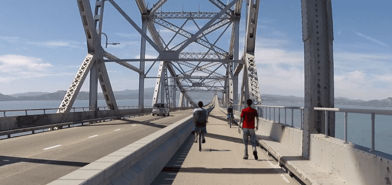
Have You Tried the Bay Bridge's Bike/Pedestrian Path?
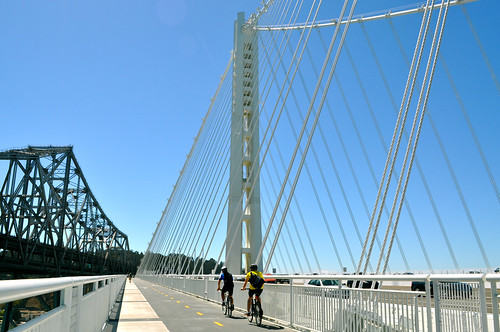
(Two people enjoying the toll-free, bicycle-pedestrian path along the new Bay Bridge span. Photo credit: Sharon Hahn Darlin)
The bicycle and pedestrian path along the new East Bay span of the Bay Bridge has proved incredibly popular, even though one still can’t completely reach San Francisco by bicycle or foot. People just really like recreating outdoors, enjoying breath-taking views in one of the most beautiful parts of California– who knew?
Have yet to go for a walk or ride? Enjoy a virtual tour of ascending and descending the bicycle-pedestrian path by bike, courtesy of KQED SCIENCE:
(Ascending. Video credit: KQED SCIENCE)
(Descending. Video credit: KQED SCIENCE)
Once completed all the way to San Francisco, popularity of the bicycle-pedestrian path will surely soar, for both commuting and recreational purposes. However, until then, the completed East Bay span still provides some unique and fantastic views worth seeing. If you’d like to check out the new path, be sure to get details about how to access the path (helpful map included) and its winter hours from the bridge’s website.
Olympic Corridor Trail Connector Study (2013)
Contra Costa County, together with the cities of Lafayette and Walnut Creek are conducting a planning study to examine a preferred alignment for a feasible alignment and a preferred alternative for a pedestrian/bicycle facility from the Lafayette-Moraga Trail to the Iron Horse Trail in downtown Walnut Creek. Review the study area map.
The first Community Workshop will be held Thursday, December 5 at 6:30 p.m. in Walnut Creek.
6:30-8:30 pm
Multi-Purpose Room
Parkmead Elementary
1920 Magnolia Way
Walnut Creek, CA 94595
[google map]
The first Community Workshop will be held Thursday, December 5 at 6:30 p.m. in Walnut Creek.
6:30-8:30 pm
Multi-Purpose Room
Parkmead Elementary
1920 Magnolia Way
Walnut Creek, CA 94595
[google map]
The specific purpose of the Community Workshop is to capture community ideas about the preferred alternative and the criteria that will be used to select the recommended alignment.
After the Community Workshop a preferred alternative will be selected, designed and studied for feasibility and cost. A second Community Workshop will be held to present the conceptual drawings and design elements for Preferred Trail Alternative and to receive comments. Public comments will be incorporated into the Final Study Report.
Timelapse: Creating A Pedestrian Plaza
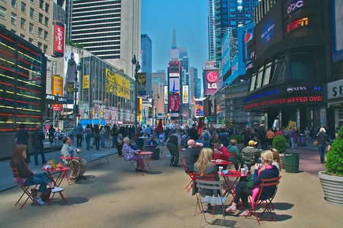
Time Square pedestrian plaza. Photo credit: Ed Yourdon
New York City has undergone some major changes in recent years from a transportation standpoint. One of the boldest and most visible changes has been the creation of pedestrian plazas throughout the city, most notably in Times Square. Having created many acres of pedestrian space, the rapid rate at which New York has been able to implement so many plazas has been in part because of the simple implementation process. While extending sidewalks by pouring concrete can be time and cost intensive, New York has – as was done in Time Square – cheaply and quickly created plazas by merely removing automobile access on a section of street and painting over the asphalt and laid down seats for pedestrians to use. To get a better idea of what all this entails, check out the creation of one of New York’s newest pedestrian plazas, the Corona Plaza at Roosevelt Ave in Queens, in this timelapse video
Video credit: NYCDOT
Pretty spectacular thing to see, isn’t it? The Corona Plaza happens to be adjacent to a transit hub which makes one wonder, where in the Bay Area could such a plaza make sense– next to a heavily used BART station, perhaps?
Pedestrians: Rights and Responsibilities
 This morning, standing in a crosswalk, I stood 15 feet from a tractor trailer as it barreled through a red light.
This afternoon, I found this article about plain-clothed cops busting drivers that fail to yield to pedestrians.
These got me thinking: what are a pedestrian’s rights and responsibilities? What are the actual rules (not just what I wanted to shout at the truck driver)? Let’s take a gander at the definitive source for California’s rules of the road, the California Vehicle Code.
California Vehicle Code
Chapter 5. Pedestrians’ Rights and Duties
California’s vehicle code requires that “safe and convenient pedestrian travel and access, whether by foot, wheelchair, walker, or stroller, be provided to the residents of the state”. As they teach you in pedestrian-advocate school, what’s great for a wheelchair also makes life better for an able-bodies pedestrian.
The driver of a vehicle shall yield the right-of-way to a pedestrian crossing the roadway within any marked crosswalk or within any unmarked crosswalk at an intersection.
 What’s an unmarked crosswalk you ask? Let’s say you’re walking down the sidewalk, and the street comes to an intersection. The ten-foot wide piece of road that extends from the sidewalk you’re standing on across the road and to the other side is a legal crosswalk. If the crosswalk is painted, it’s a “marked crosswalk.” If there’s a traffic signal or stop sign, it’s a “controlled intersection.” But whatever the paint or signage, it’s a legal crosswalk, and vehicles are required to yield to pedestrians.
A study by the Berkeley Traffic Safety Center found that 35 percent of drivers surveyed did not believe pedestrians have the right-of-way at marked crosswalks. Just because the law if on your side, look both ways.
(Photo from Atlanta-based Peds.Org)
But if you’re crossing away from a legal crosswalk, yield to drivers, because that’s where they have the right-of-way. Unless there’s street construction or the crosswalk is out of service, in which case pedestrians should walk along the roadway to the left-side, and be careful.
 Whenever any vehicle has stopped at a crosswalk to permit a pedestrian to cross the roadway the driver of any other vehicle approaching from the rear shall not overtake and pass the stopped vehicle.
If you see a car stopped for a pedestrian in a sidewalk, you’re legally obligated to also stop. The pedestrian is less likely to see a second car coming behind a stopped car.
A totally or partially blind pedestrian carrying a predominantly white cane (with or without a red tip), or using a guide dog, the pedestrian has the right-of-way. There are steep fines for using white canes in this way if you aren’t actually blind.
Also, no person may stop a vehicle unnecessarily in a manner that causes the vehicle to block a marked or unmarked crosswalk or sidewalk. Don’t block the sidewalk, either – leave enough room for a person in a wheelchair to comfortably pass.
Be safe out there!
City of Pleasant Hill Bicycle and Pedestrian Master Plan meeting January 11, 2011 6-8 PM
What: Public Meeting for Pleasant Hill citywide bicycle and pedestrian master plan project
When: Tuesday, January 11, 2010 from 6-8 PM
Where: Pleasant Hill City Hall, 100 Gregory Lane, Pleasant Hill, CA 94523 – Large Community Room
 The City of Pleasant Hill will host the second public meeting on its citywide Bike/Ped Master Plan project next Tuesday (January 11th) between 6pm and 8pm. Meeting location: at the City Hall Large Community Room. The draft list of recommended bicycle and pedestrian projects will be presented. Meeting materials will posted on the project website (www.walkandbikepleasanthill.com) at the end of this week.
Trail from Castro Street to Point Molate in Richmond under design

The Bay Trail Connection to Point Molate is a planned multi-use pathway that will provide non-motorized access from Richmond to Point Molate closing a one-mile gap in the San Francisco Bay Trail.
The route begins at the Castro Street Bus Terminal and ends near the Richmond/San Rafael Bridge Toll Plaza, connecting to the future Pt. Molate trail via an existing tunnel at foot of bridge.

Goals:
“Provide an off-street route to Point Molate that is safe, enjoyable, continuous and accessible for pedestrians and bicyclists.”
- Close a gap in the Bay Trail
- Encourage bicycling and walking
- Balance trail user and adjacent uses needs
News and Image Credit: Richmond Bicycle/Predestrian Advisory Committee. Proposal PDF.
Its Open! Treat Boulevard Bike/Ped Crossing Ribbon Cutting Photos
511 Contra Costa was present at the Treat Boulevard bike/ped crossing ribbon cutting ceremony on Oct 2, 2010. Here are some photos of the ribbon cutting ceremony.

")
A video of the first cyclists to cross the new bridge.
Check out our post with additional photos and a timeline of the project, or read more about the Grand Opening of the Contra Costa Centre & the Treat Boulevard overcrossing at:
Contra Costa Times
CLAYCORD.com
SFGATE.com