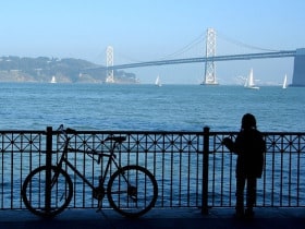
Good news for those hoping to make the journey from Yerba Buena Island to San Francisco by foot or bicycle! Plans for a bicycle and pedestrian pathway across the western span of the Bay Bridge may be one step closer towards fruition.
The state Assembly Committee on Transportation passed Senate Bill 1061, which would allow a portion of Bay Bridge toll funds to be spent on the project, yesterday afternoon. The bill passed the Senate on June 1 and will now go to the state Assembly Committee on Appropriations to determine whether the Bay Area Toll Authority should be permitted to use toll funds on construction of the pathway. If the bill passes, the pathway will open in 4 years.
The largest hindrance to the bill is cost- the original cost was estimated to be between $168 and $350 million 10 years ago and a new estimate will not be available until spring 2011. Additionally, toll funds are restricted due to safety costs.
MacDonalds Architects have proposed a design for the pathway, which would provide a “unique means for [pedestrians and cyclists] crossing the bay.” The plans include a plaza for visitor congregation, lampposts in place every 60 feet, and accessibility points for wheelchairs, bicycles, pedestrians, and maintenance vehicles.
Image by macinate
Tag: san francisco
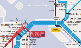
New Unofficial Transit Map of All Rail in the Bay Area
 San Francisco Cityscape has just released its third version of a Bay Area rail map that includes all lines:
“The last version was more detailed; like the new BART map, it listed destinations that couldn’t be fit on the map. But we’d like to think that this version combines the simplicity of the BART map with a relatively accurate rendering of geography, and it includes some detail that the BART map doesn’t, like major Muni stops.”
Read more at the San Francisco Cityscape website and check out the map here.
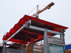
SF To Get 1100 New Solar Powered Bus Shelters
The first of 1,100 new solar powered bus shelters was unveiled yesterday in San Francisco. The solar power generated by the structure’s wavy red roof will be used to power LED lighting, the NextBus display, intercom and wireless routers.

You can check out the full story on SF Streets Blog.
For more detailed photos have a look at the images from Mike Chino and Ryan Hughes at Inhabitat.
