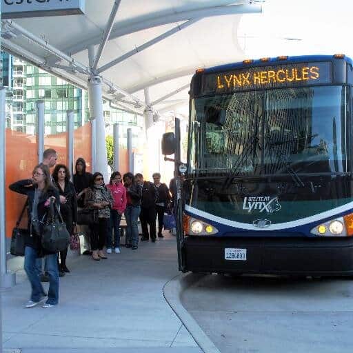
If you ride WestCAT’s LYNX route, get ready to start seeing double!
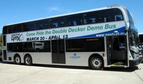
AC Transit handed off a shiny, new 80-seat double-decker bus (on loan from manufacturer Alexander Dennis) to WestCAT earlier this week, and it went into active use today!
The double-decker bus will be part of the LYNX fleet for a demonstration period through March 26-April 13. In order to give everyone an opportunity to experience the new vehicle, the bus will be scheduled for use on various LYNX runs. WestCAT will use Twitter (@wccta), Facebook (facebook.com/wccta), and their website to advise customers on which runs the bus will be traveling on a particular day.
 WestCAT is testing the bus to see if double-deckers would be a useful addition to the LYNX fleet. Those who ride the double-decker bus will be asked for feedback, which will be used to help the agency determine whether to consider acquiring similar buses. If the WestCAT Board of Directors decides to purchase double-decker buses, customers could see them in service as early as 2017.
For more information about the double-decker bus demonstration, visit westcat.org or call (510) 724-3331.
Tag: transit
Concord's Bicycle & Pedestrian Master Plan Workshop – April 8, 2015
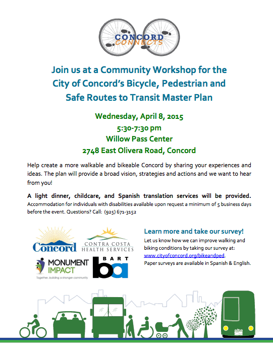 You’re invited to help create a more walkable and bikeable Concord at a Bicycle & Pedestrian Master Plan Community Workshop on Wednesday, April 8.
Community input is vital to the creation of the Bicycle & Pedestrian Master Plan, which seeks to improve access for pedestrians and bicyclists to the City’s BART stations, guide investments in infrastructure, improve connections between the regional trails network and downtown, and improve safe access between schools, jobs, downtown, and other important areas of the city.
A light dinner, childcare, and Spanish translation services will be provided.
Accommodation for individuals with disabilities is available by request a minimum of 5 business days before the event. For more information, view the event flyer or call (925) 671-3152.
To give immediate feedback on how Concord might improve walking and biking conditions, or to read more about the Bicycle & Pedestrian Master Plan, visit the City of Concord’s information page.
Vital Signs: A New Website from the MTC (2015)
In late January, the Metropolitan Transportation Commission unveiled their new Vital Signs website. Drawing from over 20 years of data, the website offers interactive, customizable charts and graphs on various aspects of transportation in the Bay Area. According to the MTC, the idea behind the project is to allow Bay Area residents, “to track the region’s progress toward reaching key transportation, land use, environmental and economic policy goals.” The MTC plans to add land use and economic development data to the site in the spring and data relating to environmental and safety questions in the summer.

Because of the interactive nature of the site, users can essentially create their own charts and graphs by choosing which cities, counties or metro areas are displayed. It’s a way to track both changes over time as well as differences between communities and regions. You can select various transportation performance indicators, called ‘measures’, relating to commuting, congestion, transit reliability and ridership, traffic volume, pavement condition, bridge and transit condition, and transit system efficiency.
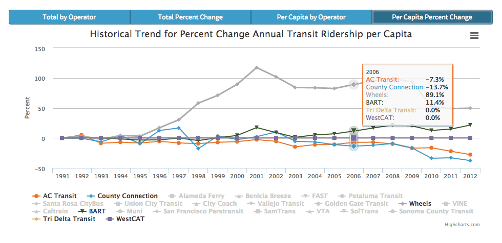
It’s quick and easy to change a chart or graph to reflect the information you want to see. For example, if you visit Vital Sign’s ‘Transit Ridership’ page and scroll down to ‘Local Focus’, by clicking on the names of transit agencies you can select/deselect them. In this particular example, the result is a Contra Costa-focused graph:
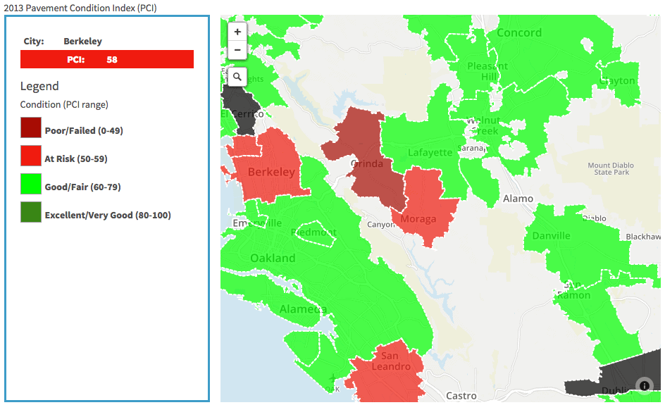
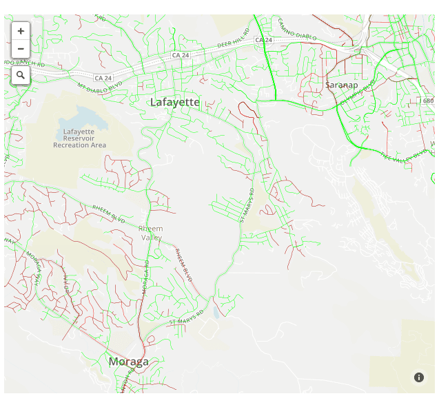
Want to know what pavement conditions are like in your area? You can see general results or street-by-street results depending on how much you zoom in:
For people who want to go beyond the interactive site and work with the raw data, the MTC has made it easy to access. Just click on the ‘Data Center’ icon in the website’s top-right corner.
You’ll find the new website at vitalsigns.mtc.ca.gov. For a video tutorial on how to use the Vital Signs website, check out the video below:
Transit Service on Martin Luther King, Jr. Day 2015
Some transit agencies will be operating on non-weekday schedules on Martin Luther King, Jr. Day – Monday, January 19. Here are the transit schedules which will be in effect:
- County Connection: Regular weekday schedule
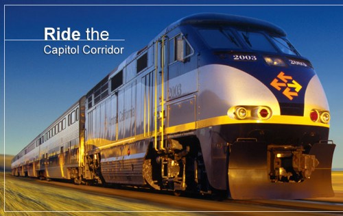
- Capitol Corridor: Regular weekday schedule
- BART: Saturday schedule
- Wheels: Enhanced Saturday schedule; No service on Rapid
- WestCAT: Express J, DAR, Local (11, 19) – Saturday schedule; LYNX – Limited Holiday service
- AC Transit: Sunday schedule
- Tri Delta Transit: Sunday schedule (only Route 392, 393, 394 and 395 in operation)
Americans Taking Transit in Record Numbers (2014)
A recent report released by the American Public Transportation Association (APTA) shows that people in the US are taking transit in record numbers. This high level of ridership hasn’t been seen since 1956, with almost 10.7 billion trips taken in 2013 — making it the eighth consecutive year with over 10 billion trips on public transportation.
Two of the important factors involved in the rise in ridership are economic recovery and the investments made by transit agencies to expand systems and improve services. APTA President Michael Melaniphy said, “When more people are employed, public transportation ridership increases, since nearly 60 percent of the trips taken on public transportation are for work commutes… We’re seeing that where cities have invested in transit, their unemployment rates have dropped, and employment is going up because people can get there.”
An interesting side-note is that the increased demand for public transportation flies in the face of conventional wisdom that past a certain price point, transit use rises and falls with gasoline prices. In 2008, with gas prices between $4 and $5 a gallon, the number of transit trips taken (10.59 billion trips) was still lower than for 2013 (10.65 billion trips), when gas averaged under $4 a gallon.
Will the demand for transit continue to grow? Based on the data, Mr. Melaniphy says it will. “There is a fundamental shift going on in the way we move about our communities. People in record numbers are demanding more public transit services and communities are benefiting with strong economic growth… This is a long-term trend. This isn’t just a blip.”
Follow the links for more facts from APTA’s 2013 report or to view the complete report.
Active Transportation to Get $360 Million (2014)
Caltrans, regional transportation agencies and the federal government have combined funds to provide $360 million in grants for the Active Transportation Program (ATP). Active Transportation is a term used to describe walking, biking, and transit. The funds for ATP will be targeted at projects like bike lanes, safer intersections for pedestrians, safety improvements leading to and around transit stops, and non-infrastructure programs like Safe Routes To School safety education outreach.
Jeanie Ward-Waller is the California advocacy organizer for the Safe Routes to School National Partnership. She said this is the most money by far that has been offered to improve walk/bike routes. But she said that it is also unique because the priorities for awarding the money are not just about transportation. Part of the decision about awarding the money will be based on potential boosts to public health. Some money is earmarked for projects in disadvantaged communities. “It’s watershed in terms of supporting walking and biking, but it’s also a watershed in how it is being targeted,” Ward-Waller said. “I think it’s a new standard about how we are approaching transportation and prioritizing things like public health and sustainability and making sure equity is a lens.” Read the full article in California Report.

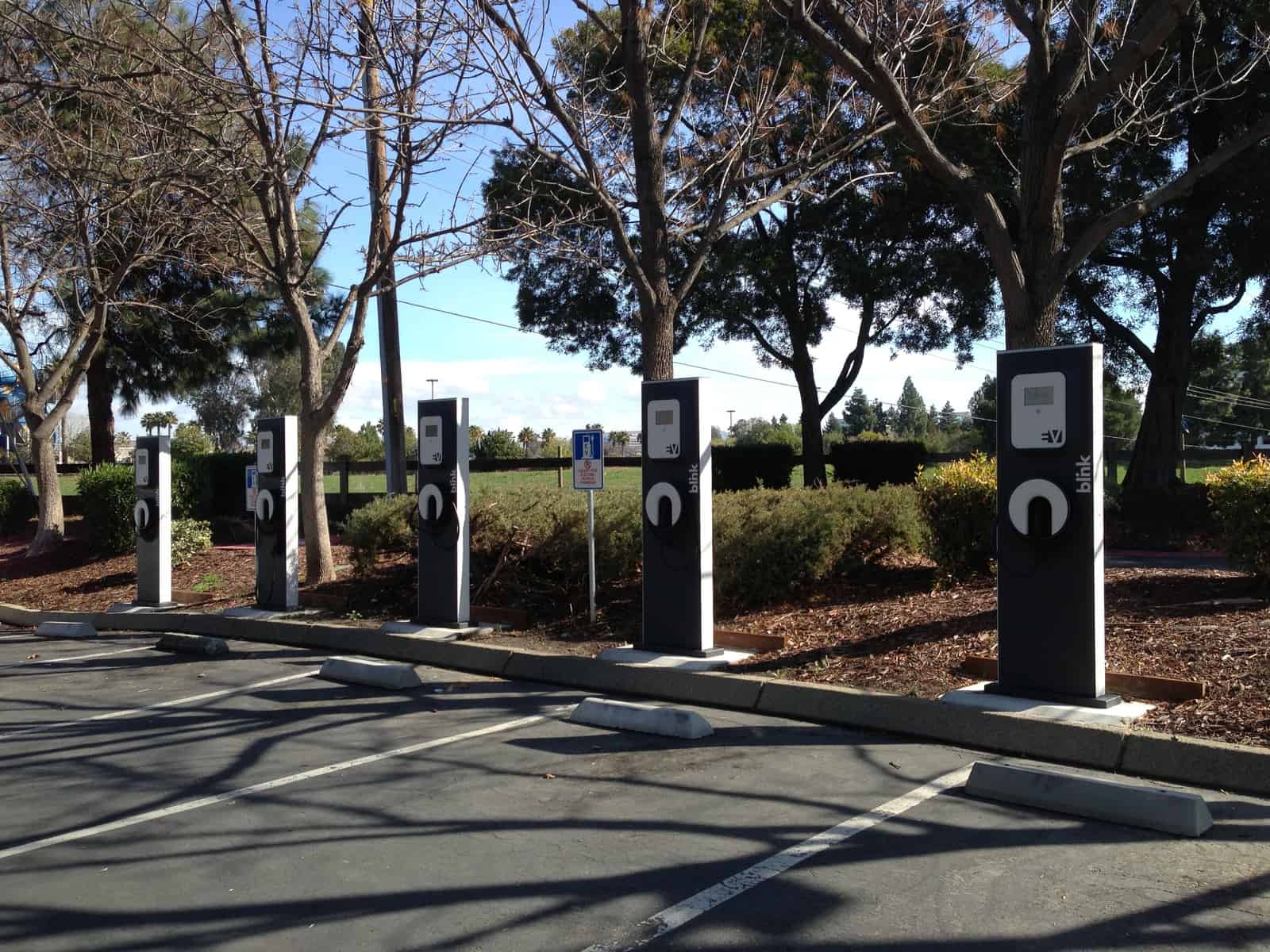
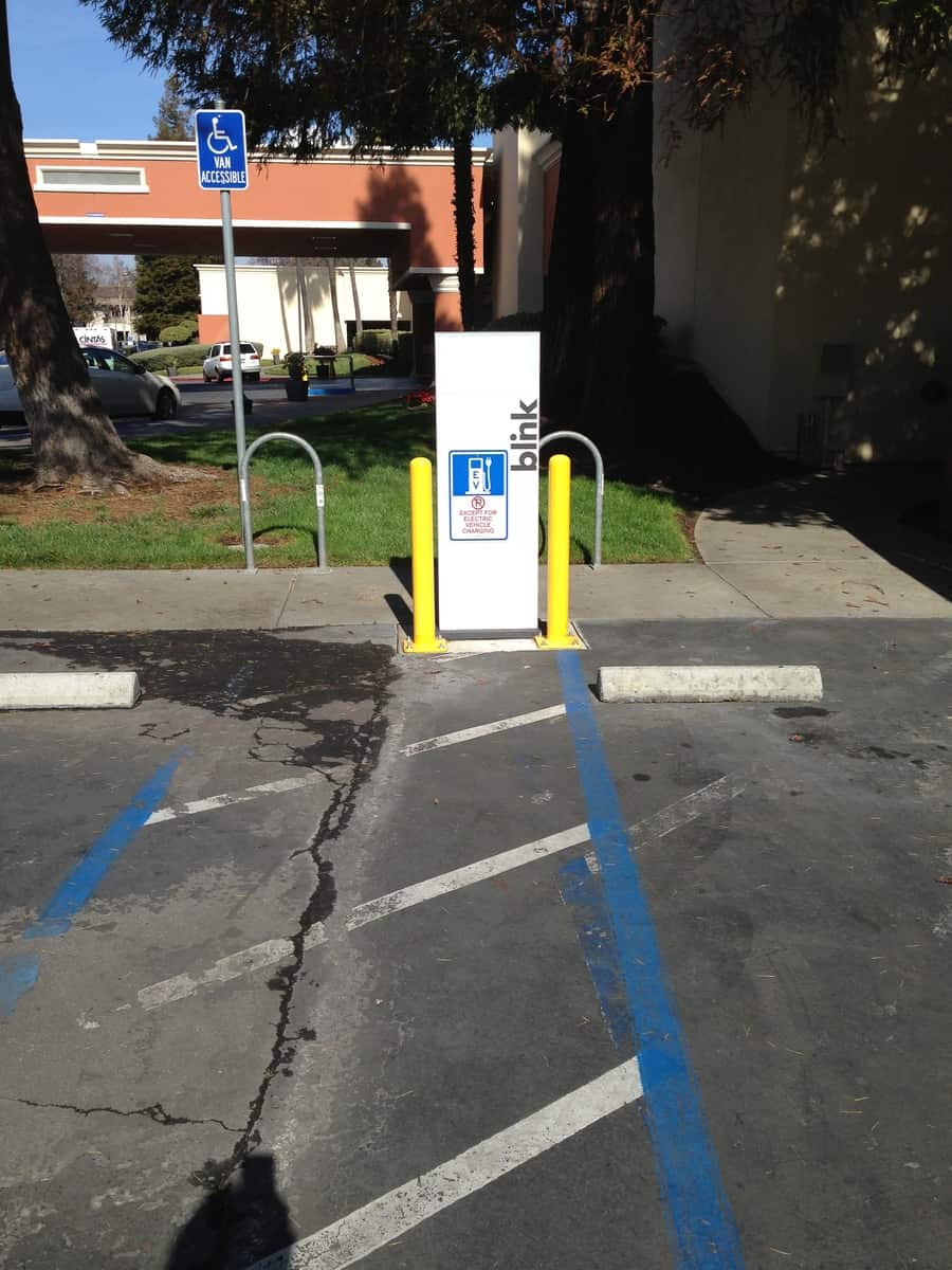
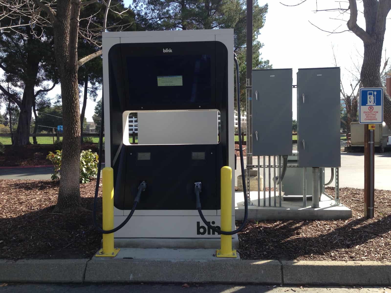
Hilton Concord Employs Commute Alternatives (2014)
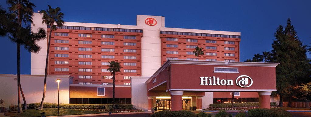
Staff recently visited the Hilton Concord as part of the Contra Costa Green Business Program certification process. We were delighted to learn that the Hilton encourages both hotel employees and guests to think about using alternative ways of traveling.
- Hilton employees are eligible for pre-tax commuter benefits to pay for transit expenses
- Nearly all employees live within a 10 mile radius of the hotel
- Around 50% of employees take the bus, bike or walk to work. A County Connection bus stop is located in front of the hotel entrance and the Iron Horse Regional Trail runs behind the property
- Bike racks are available to employees and guests alike


- A complimentary shuttle to and from the Concord BART station is available to hotel guests
- Eight (8) electric vehicle plug-in vehicle charging stations are available to the public; six (6) Level II and two (2) DC fast chargers on the Blink Network
We can’t wait to see what Hilton Concord does next!
See other sustainable practices Hilton Concord has implemented.
Freeway Maps as Public Transit Corridors
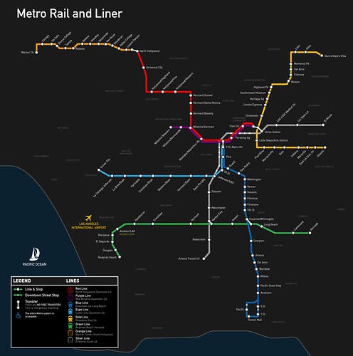
A map of Los Angeles’ current rail network. Image credit: Kriston Lewis
Los Angeles is being hailed for its steady revival of the thriving rail system it once had, but the current plan to create a convenient network that connects the whole county is still 30 years away. The Los Angeles rail system has seen rapid growth in usage with the most recent addition, the Expo Line, which was completed earlier this year.
Now, let’s imagine what the freeway system in L.A. would like like if it was a rail system? We have an idea thanks to “Stonebrown Design,” who has put together maps of L.A.’s freeway system as though it were a rail system:
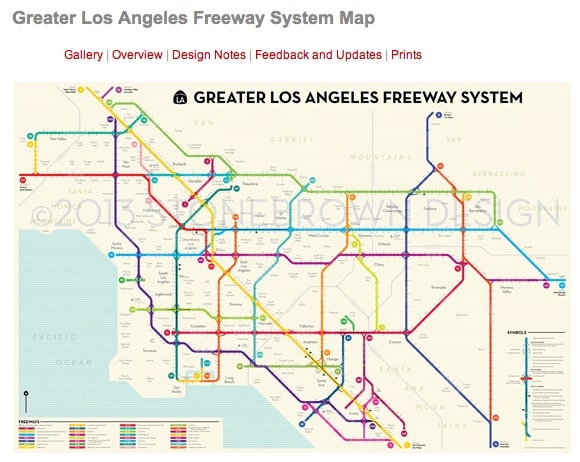
Los Angeles’ freeway system, seen in rail map form. Screen-grab via: Stonebrown Design
Comparing the above Stonebrown Design map to the current Metro Rail map there is a clear visualization demonstrating that rail doesn’t serve as many people as the freeways do (yet!).
To see more detailed maps of L.A.’s freeways with a “public transit vision,” head over Stonebrown Design’s Greater Los Angeles Freeway System Map page (soon you’ll be able to purchase prints as well, due to a rather successful Kickstarter campaign).
Student Bag Artwork Contest (2014)
Calling all student artists!
We need your creative talent to design a cool graphic to be featured on the 511 Contra Costa reusable bag that is distributed across Central and East Contra Costa County. The winning artist will receive a $50 gift card to the movies and his/her artwork featured in the latest edition of our reusable bag!
What is the theme?
“Explore New Ways to Get Around”: carpool, transit, bike, skateboard and walk. Your artwork should show how these ways environmentally-friendly ways of getting around help reduce pollution and promote cleaner air.
What are the requirements?
- Use the 17×11 cardstock paper supplied by 511 Contra Costa.
- Use of up to three (3) colors is allowed. (Note: Black is considered one color. You can use the white background of the paper as another source of color.)
- Include three (3) logos in the artwork:
– 511 Contra Costa (should be featured prominently)
– Contra Costa Transportation Authority
– BAAQMD Transportation Fund for Clean Air
4. Sign your work!
What are the contest rules?
- Artwork contest ends Friday, February 28, 2014. Entries due by 5 pm Thursday, February 27, 2014 at City of Antioch City Hall; or Friday, 12:00 noon,February 28, 2014 at 511 Contra Costa in Pleasant Hill.
- Artwork submitted must be from a student enrolled in a middle school within the cities of Antioch, Brentwood, Clayton, Concord, Martinez, Oakley, Pittsburg, Pleasant Hill, Walnut Creek and the surrounding unincorporated areas.
- He/she must have permission of parent/guardian to enter in the contest by acknowledging and signing the Parent Guardian Release Form.
BART Fares to go up January 1, 2014
 BART fares will increase by 60 cents for the longest trip and 25 cents for shorter trips on January 1, 2014. The fare hike is part of the BART’S regularly scheduled inflation-based increase program established in 2003.
The agency’s nine-member elected board has earmarked the estimated $325 million in additional fare proceeds through 2020 to pay for new rail cars, improvements at its Hayward maintenance yard and a new train control system.
For full details, see the updated fare chart.
Transit and Vanpool Commuter Benefits to be Reduced in 2014
 Transit riders and vanpoolers who take advantage of pre-tax commuter benefits with their employer will find that their maximum monthly limit decrease to $130 starting January 1, 2014 from $245 in 2013.
The American Taxpayer Relief Act of 2012 (HR 8) restored the pre-tax transit and vanpool commuter benefits to be on par with the qualified parking benefit temporarily for the 2013 calendar year. That parity ends December 31, 2013.
At this time, the 2014 monthly limits for qualified monthly transportation benefits are:
- up to $130 per employee per month for public transportation and vanpool
- up to $250 per employee per month for qualified parking, or
- up to $380 per employee per month for both public transportation and qualified parking
Qualified bicycle commuting reimbursements will remain unchanged at $20 per month in the new year.
Congress will have to pass legislation to make any changes to the 2014 transit and vanpool limits.
See the IRS Bulletin regarding the new monthly limits.
For more information about Transportation Fringe Benefits, visit the Internal Revenue Code Section 132 (F), as amended by TEA-21, Title IX, Section 910.
Bay Area Commuter Benefits Program Public Workshop (2013)
The staff of the Bay Area Air Quality Management District (Air District) and the Metropolitan Transportation Commission (MTC) will conduct public workshops to present, discuss, and receive comments on draft Regulation 14, Rule 1: The Bay Area Commuter Benefits Program.
What is the Bay Area Commuter Benefits Program?
California Senate Bill 1339, signed into law in fall 2012 created the Bay Area Commuter Benefits Program (Program). Employers with 50 or more full-time employees in the Bay Area are required to provide commuter benefit options to their employees.
What is the Bay Area Commuter Benefits Program?
California Senate Bill 1339, signed into law in fall 2012 created the Bay Area Commuter Benefits Program (Program). Employers with 50 or more full-time employees in the Bay Area are required to provide commuter benefit options to their employees.
- Employers can select one of the following four commuter benefit options to offer to their employees:
- The option for employees to pay for their transit or vanpool expenses with pre-tax dollars, as allowed by current federal law;
- A transit or vanpool subsidy to reduce, or cover, employees’ monthly transit or vanpool costs;
- A low-cost or free shuttle, vanpool, or bus service operated by or for the employer; or
- An alternative method that would be equally as effective as the other options in reducing single-occupant vehicle trips (and/or vehicle emissions).
Building on the success of similar programs adopted in the cities of San Francisco, Berkeley and Richmond, as well as the San Francisco International Airport, the Program facilitates a regional approach to encourage the use of sustainable commute modes, such as public transit, ridesharing, bicycling and walking, in the effort to reduce greenhouse gas emissions from the transportation sector, reducing traffic congestion and improving air quality.
In the Bay Area, where these programs are already in place, most employers have chosen the pre-tax option (option 1 above), which can provide economic benefits to both employers and employees through tax savings. Employers can reduce payroll taxes (approximately 9 percent of subject wages), and employees can lower their commute costs by up to 40 percent.
Plan Implementation
The Bay Area Air Quality Management District and the Metropolitan Transportation Commission are currently developing plans for adopting and implementing the Program, and will conduct public workshops to present, discuss and receive comments on the Program. View dates and locations of upcoming workshops.
See also New Bay Area Commuter Benefit Policy
Google Maps Transit Directions Move In RIght Direction
A major update is in the works for Google’s Maps relative to transit directions could be very exciting. As noted on Human Transit, key changes are being made to Google’s transit directions, including:
- Offering alternatives based on frequency of transit lines
- Mapping other transit lines in the area along one’s route
- Accounting for lines whose paths duplicate service over a section of a trip
Imagine using Google Maps for transit to map your transit trip. Under the current version of Google Maps, you may routed to a bus line that includes a transfer to a bus line that only runs every 30 minutes, because it makes for the “shortest” trip since you’ll only have to wait a minute to catch it. It could be you miss that bus by a minute due to an unexpected delay and suddenly find yourself waiting a half hour until the next bus arrives. In the updated Google Maps directions, you will be also be shown nearby transit lines that, while they may be a little further away from your transfer point, run more frequently and thus are more reliable and convenient in catching to reach your destination on time. In short, Google will show a more complete menu of transit possibilities, which will show more realistic and reliable routes and leave greater options for users.
To learn about other Google Maps direction updates, see the below video:
Video credit: Google Maps
For more insightful commentary on the coming Google Maps transit updates, be sure to check out Seattle Transit Blog and Human Transit.
Don't Forget, The County Connection 2013 Summer Youth Passes Now Available!
Photo credit: La Wad
Just a quick reminder, The County Connection’s Summer Youth bus passes are now on sale– here’s the official announcement:
Following a decades-old tradition The County Connection is offering a deeply discounted Summer Youth bus pass to help students get around during the summer.
The 20-Ride Summer Youth Pass sells for $15 and is available now for youths age 6-18. Summer Youth passes are accepted on all County Connection regular fixed-route buses. If using the Summer Youth Pass on an Express route at additional quarter is needed.
County Connection allows more than one person to use a single bus pass, making it easier for families with multiple children, or for those planning group outings.
The pass is valid from June 9 through September 30th, and is available through the mail, at most sales outlets, or online. For more information about this program, call Customer Service center 676-7500 or visit www.countyconnection.com
Need inspiration for how you can put a Summer Youth pass to good use? Check out our Transit and Trails post!
Two Thumbs Up For The County Connection's Real Time Bus Tracker
About half a year ago, the County Connection introduced “Bus Tracker,” the latest upgrade to County Connection’s on-board computer system that provides real time arrival predictions for any bus stop in the system. Since the upgrade, the agency has received nothing but positive feedback from transit riders. Take, for example, this comment from Gabe Griffith, president of the Contra Costa Chapter of the California Council of the Blind:
“Thank you for introducing Bus Tracker. It works great with the VoiceOver speech output on the iPhone. I’ve used it several times and it’s always been accurate. When I get my message that the bus is due to arrive at my stop, the bus shows up within a minute. I like that if a bus is running a little late, Bus Tracker will give actual arrival times, rather than scheduled arrival times. Two thumbs up!”
Real-time data that allows riders to track buses is the kind of improvement that truly makes transit more accessible, and convenient to the public– two thumbs up, indeed!
For a refresher of what exactly Bus Tracker is and how you can take advantage of it, see the below video
Video credit: h2MediaLabs
(Note: Passengers only need access to the Internet to see where buses are on-route, and to see when the next bus is predicted to arrive at any given stop. Riders are encouraged to set up a personalized account to receive arrival alerts via text or email messages. Simply visit www.countyconnection.com and click the Bus Tracker button to get started.
County Connection is currently in the process of creating a downloadable application to make using Bus Tracker even more convenient on mobile devices.)
A Map of California Rail (2013)
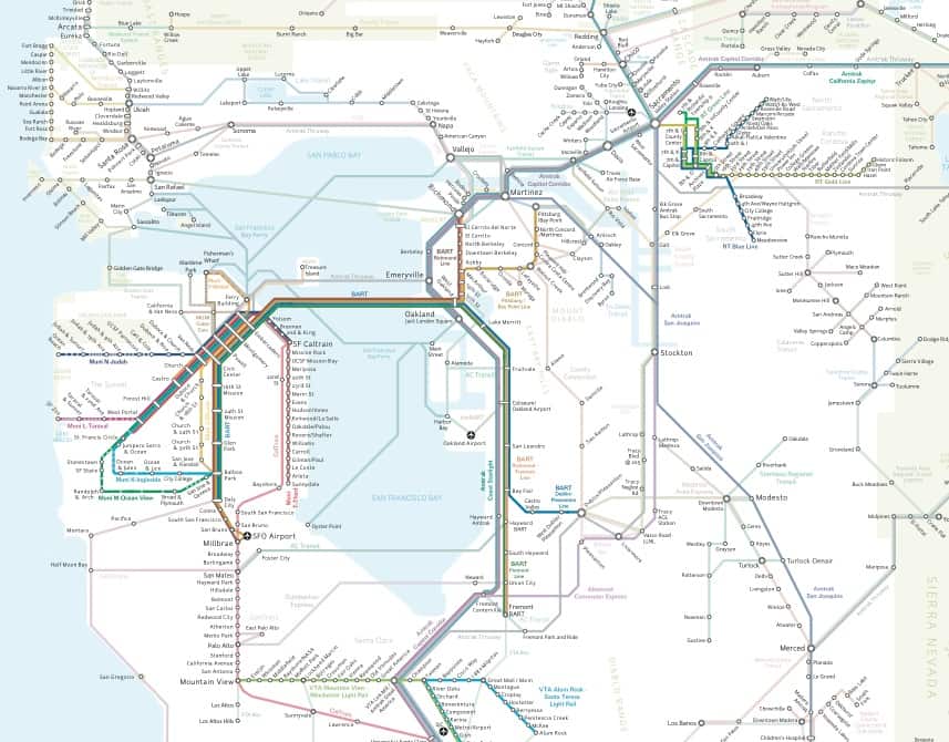
Bay Area rail lines– more extensive than you thought, huh? Screen grab via: California Rail Map
It’s not hard to access a map of California’s highway system– from google maps to regional maps, highways are visible and this comes as no surprise. What is surprising however, is that it is only now has someone compiled a map of California’s extensive (and growing) rail system.
The team at California Rail Map has put together a map of California featuring: Amtrak, BART, Muni, VTA, Caltrain, Altamont Commuter Express, Sacramento Regional Transit, NCTD, San Diego Trolley, LA Metro, and Metrolink (in addition to key bus and ferry connections between rail services).
The end result – a rather impressive map – highlights many possible ways to explore California’s gold, car-free!
For more information, head over to California Rail Map’s website. And rail enthusiasts who just can’t get enough, make sure to check California Rail Map out on facebook for more impressive maps, infographics, and conversation about high-speed rail.
Oh yeah, and don’t forget to download your own California Rail Map.
Seeing One Day in San Francisco Through Transit Activity
San Francisco is full of hustle and bustle. Have you ever wondered what that looks like through the eyes of public transit?
Youtube user SLT Transit put together a time-lapse video of transit activity over a typical day in San Francisco that demonstrates through its mesmerizing patterns how vital public transit is to city’s transportation system. Check out the video below:
Recognize your bus route? Video credit: SLT Transit
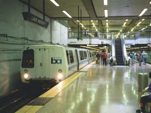
Nice And Clear: New Bay Area Transit Information (2013)
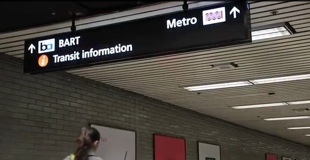
Look for this next time you’re in a downtown San Francisco BART station. Screen grab via MTC
The Metropolitan Transportation Commission recently installed new information centers including street maps, schedules, transfer info, and large LCD screens with real-time departures on sidewalls at the Civic Center, Montgomery, and Embarcadero BART stations in San Francisco. The sleek, highly-visible updated information centers are part of the MTC’s Transit Connectivity Plan to make the Bay Area’s public key transit hubs more friendly to users. The new information centers are clear and intuitive but the most welcoming feature is undoubtedly the live screens with real-time transit arrival information. Now riders can tell at a mere glance whether they should rush to catch their train, or whether they have time to grab a cup of coffee– no more running down to the platform simply because you hear a train arriving.
The new information centers are indicated by, and signed to, large orange circles with an “i” for information (see the picture at the top of this post) and twelve additional BART stations are slated to receive the same addition by summer 2013.
See the MTC’s video below that explains the phasing in of these new information centers and see what the already installed ones look like:
Catching the County Connection With Bus Tracker
County Connection. Photo credit: LA Wad
Back in December County Connection launched Bus Tracker – a system that provides real-time information about where the bus is and when it will arrive at the bus stop. With just over two months of operation the Bus Tracker alert system has quickly earned the praise of transit riders. See the article below “Bus Tracker Earns County Connection Passenger Praises” via The County Connection with added emphasis at particularly striking points in the article.
Last summer when David Shen heard County Connection would offer real time bus arrival prediction, he began to spread the word among his co-workers at Chevron in Bishop Ranch. Bus Tracker has now been installed on all County Connection’s fixed-route buses and the software uses GPS location data to predict arrival times. Buses transmit their location every thirty seconds via the Sprint network enabling Bus Tracker to predict arrival times and make bus location information available to the public on the web.
“Bus drivers really do a good job of keeping the buses on time in normal traffic conditions,” said Shen, a regular County Connection passenger, “but all it takes is a little fenderbender during the commute hour for the freeways to back up. Since Bus Tracker went live last month I’ve been able to completely eliminate my wait-time at the stop.”
All passengers need is access to the internet to see where buses are on-route, and to see when the next bus ispredicted to arrive at a stop. The map view uses the familiar Google maps as a base to show buses progressing along the transit routes. Riders can view the upcoming bus arrival times by selecting any bus stop in thesystem.
“Near the end of my day, I open Bus Tracker on my computer or smartphone and keep an eye on the next bus as I finish up, then time my departure based on when the bus is due to arrive,”continued Shen. “County Connection deserves kudos for installing this system.”
The implementation of Bus Tracker is the latest upgrade to County Connection’s on-board computer system. Having real-time arrival information is particularly important for a suburban system because the bus comes less often than in an urban area. “The new system is more appealing to new riders because the uncertainty is removed” said Anne Muzzini, director of planning at County Connection. “We have come to expect up to date, current information via the web and County Connection riders now have this for their bus route.”
Because customer service agents can see where buses are and what the predicted arrival time is, even riders without access to the internet can have more accurate information. Prior to being able to use Bus Tracker customer service agents relied on the“scheduled” times. Now they can see if a bus is caught in traffic.
Riders are encouraged to set up a personalized account to receive arrival alerts via text or email messages. Simply visit www.cccta.org and click the Bus Tracker button to get started or to set up a personalized account.
County Connection operates a fleet of 112 clean diesel and 9 hybrid diesel buses in fixed route service and 63 gas powered vans in door-to-door service. For assistance with Bus Tracker or get information on bus routes from Customer Service staff, please call(925) 676-7500.
Commuter Benefits Raised for 2013
 The American Taxpayer Relief Act of 2012 (HR 8) has restored the pre-tax transit and vanpool commuter benefits to be on par with the qualified parking benefit. For the 2013 calendar year:
- up to $245 per employee per month for vanpool and all public transportation
- up to $245 per employee per month for qualified parking, or
- up to $490 per employee per month for both public transportation and qualified parking
The effective date for the revised limits above allows for retroactivity back to January 1, 2012 if an employer so chooses under Sec. 203.
In 2012, the IRS Transportation (Commuting) Benefits rolled back to pre-2009 levels of $125 per month (adjusted for inflation) for vanpool expenses and public transit passes. The maximum was temporarily raised to $230 per month under The American Recovery and Reinvestment Act (ARRA) of 2009 and extended under the Tax Relief, Unemployment Insurance Reauthorization, and Job Creation Act of 2010 to equal the monthly qualified commuter parking limit.
Qualified bicycle commuting reimbursements will remain unchanged at $20 per month in the new year.
By offering pre-tax commute benefits to employees, employers can save on paying FICA payroll taxes and employees can take advantage of saving on federal withholding and FICA taxes on the amount deducted. Find out more from these third-party commute benefit administrators: Benefit Resource Inc., Clipper Direct, TranBen, TransitCenter (TransitChek), and WageWorks.
Image Credit: 401(K) 2013
Year in Review: 2012

Image credit: David Yu
511CC’s 2012 Year in Review
From the Caldecott Tunnel breakthrough to Bay Area transit agencies celebrating milestones for service, 2012 was a great year for biking, transit and transportation. Here are some of this year’s top stories.
Top Tweets
Some of our most popular tweets (number of link clicks) in 2012 linked to these articles:
Image credit: Eric Fischer
- For your viewing pleasure – BART stats on a map
- BART app map
- Caldecott Fourth Bore Medallion Design Competition (view winning and honorable mention entries here)
- Bay Bridge demolition will last longer than first projected
- BART introduces new automated Twitter feed for service advisories
- A book shelf for your bike
- How can cities make life easier for the elderly?
- Great and Not-So-Great Subway logos
- Rails-to-Trails Conservancy busts myth that “nobody walks” in Rural America
- All-electronic tolls coming to Golden Gate bridge
2012 highlights
Here are some transportation highlights from the year.
JAN
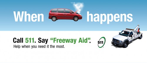
- 511 introduces Freeway Aid
- Ford unveils 2013 Fusion Hybrid
- 25 | Caltrans allocates $347 million for improving state transportation
FEB
![]()
- LAVTA retrofits 30 Wheels buses to make boarding with strollers easier
MAR
Image credit: Steve C.
- Hercules transit center project gets $4.5 million (Contra Costa Times login required)
APR
- BART releases creative commons system map for developers
- 3 | BART rolls out easier to clean seats
- 12 | BART breaks ground on San Jose extension
MAY

- WestCAT Lynx breaks ridership record
- 27 | Golden Gate Bridge celebrates 75th anniversary
- 31 | Caltrans awards $350 million to improve public transit and air quality
JUN

JUL
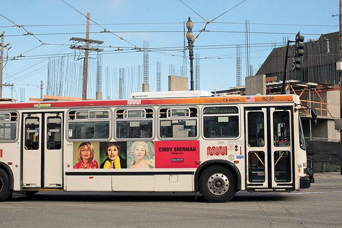
Image credit: torbakhopper
- 1 | Muni allows boarding through all doors
- 5 | Caltrans awards Contra Costa County $450,000 for Safe Routes to Schools
- 30 | Capitol Corridor begins offering eTicketing
AUG
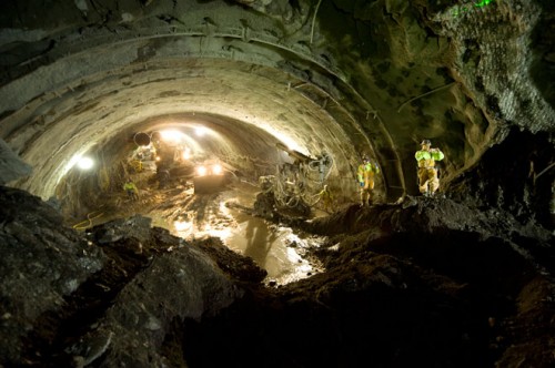
Image credit: Karl Nielsen/Metropolitan Transportation Commission
- 8 | Primary excavation of the Caldecott Tunnel Fourth Bore tunnel was completed
- WestCAT celebrates 35th anniversary
SEPT

Image credit: Bay Area Rapid Transit archives
OCT
- 5 | BART breaks ground for eBART Antioch extension
- 31 | BART breaks ridership record with more than 580,000 riders
NOV
DEC
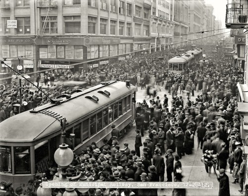
Image credit: SFMTA / John Henry Mentz
- 511CC joins Pinterest
- 5 | Caldecott Tunnel celebrates 75th anniversary
- 5 | County Connection introduces real-time tracking
- 28 | San Francisco Muni celebrates 100 years
For more interesting articles and tips on biking, transit, and transportation in the Bay Area don’t miss our Twitter feed and our blog.
Good and Better News From Google Maps!
Image credit: Prashanth dotcompals
In the realm of Google Maps, there’s good news for transit users, and better news for bike users.
First, the good news comes in an article by Jeremy Owens of the San Jose Mercury News titled “Google Maps mobile app’s transit offerings work great for novices, but hard-core Bay Area riders will want more”. Owens shares his experience with Google’s new transit app, finding some good in it:
Google has added transit lines from hundreds of cities to Google Maps as of August, and its Bay Area offerings are extensive, including small services such as the Menlo Park Midday Shuttle. The biggest addition is schedules for all of the lines it offers, making finding departure times simple and transfers between agencies more predictable.
Unfortunately, Owens sees one crucial flaw:
“I put it to the test to see if it could replace the mishmash of agency-specific transit apps I use on a daily basis to maneuver around the Bay Area. The verdict: No, because of one big flaw – the lack of real-time departures.”
Now, for the better news– Google Maps has impressively published 530,000km (that’s 329,327 miles) of bicycle infrastructure in Europe and Australia. Until recently, Google Maps did not have any bicycle specific directions or show bicycle routes and paths in Europe or Australia, which is perhaps surprising as Europe is home to countries with some of the highest bicycle mode-share in the world and Australia is seeing more and more bicycle infrastructure with each year!
Cycling directions and turn-by-turn navigations are now available in the following countries: Australia, Austria, Belgium, Denmark, Finland, The Netherlands, Norway, Sweden, Switzerland, and the UK.
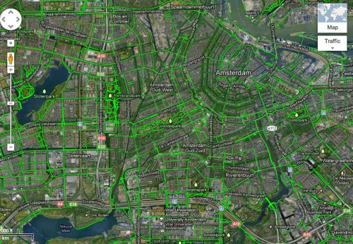
See all those green lines and dashes? They’re all bicycle paths, lanes, and routes– no wonder 50% of all trips in Amsterdam are by bike! Image via Google Maps
And in more of the”better” news, Google Maps has now added voice-guided navigation for bicycle directions [for Andriod phone users]! That’s right, cyclists can now mount their Android phones to their handlebars and receive turn-by-turn directions and navigation, as well as voice-guided directions.
Google appears to be allocating resources to accommodating multiple modes of transportation with their maps and directions. It seems to reinforce and reflect our reality– more and more people are taking to two wheels and transit, and that is great news!
BART Turns 40!
September 11th, 1972– the day BART began running trains between Fremont and Oakland. Forty years later and the backbone of the Bay Area’s transportation network is still running strong, and still expanding. In honor of the momentous milestone, here is a round up of some vintage views of BART:
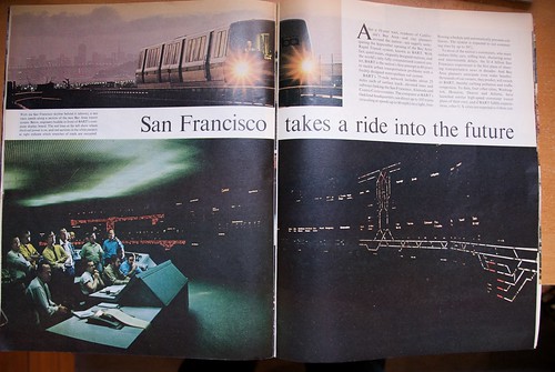
Pages from Life Magazine, August 1972. Photo credit: brian kusler
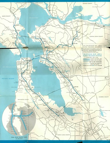
Proposed Bay Area Rapid Transit System, February 1961 Plan. Photo credit: Eric Fischer
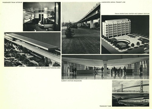
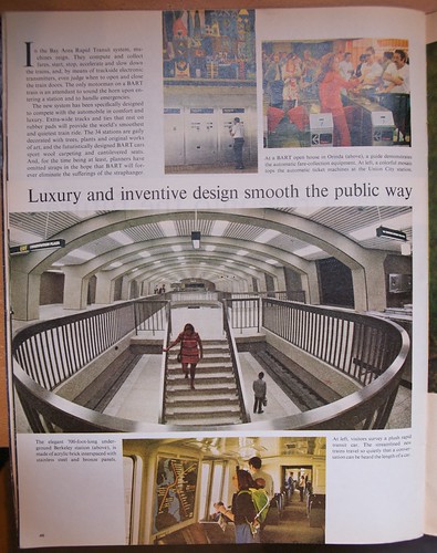
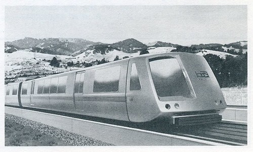
Promotional photos and renderings of BART, from San Francisco Bay Area Rapid Transit: An Investment in the Future, 1967. Image credit: Eric Fischer
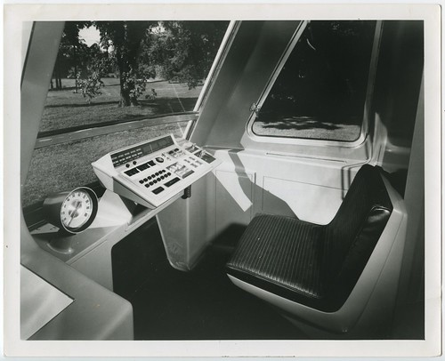
BART promotional photo of operator’s cab prototype circa 1965. Image credit: Eric Fischer

Michael Douglas searches for the bad guy, on location at the 16th Street Mission BART station, in this photo from the 1970’s tv series Streets of San Francisco. Image credit: Todd Lappin

Old BART tickets. Photo credit: Michael Mandiberg
Check out that BART logo, from 1967! Image credit: Eric Fischer
For more BART memories check out these links:
- The BART logo from 1958
- The BART system map from 1961
- Along the Way, a BART video from 1968
- An amazing collection of photos in SF Gate’s “The Birth of BART“
- SF Chronicle gives a brief history of BART’s origin with some iconic pictures, including one of President Nixon riding, in “BART, at 40, looks to build on triumphs“
- BART’s 40th Anniversary Pintrest Board
- A slideshow of 25 great vintage pics over Huffington Post
- One family’s story of BART on opening day via SF BART.
How has BART’s 40 years of service been for you– any memories you’d like to share? Let us know in the comments!
U.S. DOT Funds Bay Area Transit Improvements
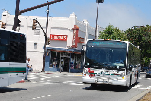
AC Transit, one of the Bay Area agencies that received federal funding to improve transportation. Photo credit: Paul Sullivan
In July the Bay Area received several grants from the U.S. DOT to improve transit.
AC Transit received $7.5 million to improve fare collection and BART received about $3 million to improve departure and arrival information.
Grants were also awarded to San Francisco, Santa Clara, San Mateo and Monterey counties to replace diesel buses with fuel efficient hybrid buses.
Read more at San Francisco CBS.