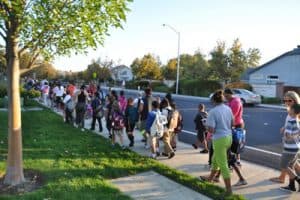
 It’s back-to-school time! If you live within walking distance of your child’s school, you might consider forming a walking school bus.
A walking school bus can be as simple as two families taking turns walking their children to school. You can definitely go bigger, by including more parents and children, but it’s easiest to start with a small group of interested families.
For details on how to start your own walking school bus, read Street Smarts Diablo’s ‘how to’ guide.
Tag: walking
Caltrans Report: Walking, Biking, Transit on the Rise (2014)
In March, Caltrans released the results from its latest California Household Travel Survey (CHTS), which looks at how we in California travel. The primary finding echoes what many suspect– Californians are driving less. The percentage of California residents walking, biking, or using public transportation more than doubled since 2000; the three modes increased in mode-share, collectively, from 11 percent to 23 percent.
Caltrans Director Malcolm Dougherty notes of the survey’s findings, “Based on this research, we can make good decisions about transportation that will improve mobility, air quality, and travel choices for all Californians and make our state a better place to live and work.”
The table below from the recent CHTS shows the exact breakdown of travel mode distribution, and how it compares to the 2000 survey:
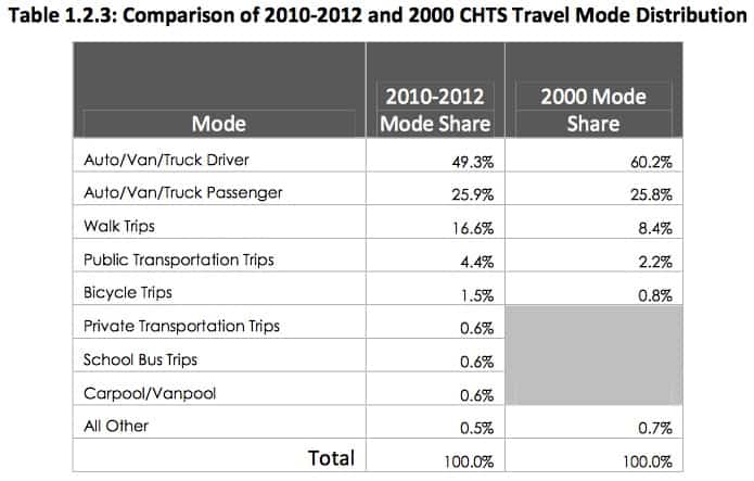 Single-occupancy cars remain the most prevalent travel mode. However it now makes up less than half of all trips, having plummeted from 60.2% to 49.3% of trips.
Interestingly, despite frequently hearing about today’s public transit and bicycling booms, the fastest growing travel mode in the Golden State over the last decade was walking, which more than doubled from 8.4% of trips to 16.6% trips. This is not to say that reports of increased levels of public transit use and bicycling are misleading, in fact the two modes doubled their respective mode-share since Caltrans’ 2000 CHTS.
The results from the survey mark a dramatic shift in the state’s travel patterns and show no signs of reversing. Looking at the numbers one can’t help but to wonder– what will the next California Household Travel Survey look like?
Active Transportation to Get $360 Million (2014)
Caltrans, regional transportation agencies and the federal government have combined funds to provide $360 million in grants for the Active Transportation Program (ATP). Active Transportation is a term used to describe walking, biking, and transit. The funds for ATP will be targeted at projects like bike lanes, safer intersections for pedestrians, safety improvements leading to and around transit stops, and non-infrastructure programs like Safe Routes To School safety education outreach.
Jeanie Ward-Waller is the California advocacy organizer for the Safe Routes to School National Partnership. She said this is the most money by far that has been offered to improve walk/bike routes. But she said that it is also unique because the priorities for awarding the money are not just about transportation. Part of the decision about awarding the money will be based on potential boosts to public health. Some money is earmarked for projects in disadvantaged communities. “It’s watershed in terms of supporting walking and biking, but it’s also a watershed in how it is being targeted,” Ward-Waller said. “I think it’s a new standard about how we are approaching transportation and prioritizing things like public health and sustainability and making sure equity is a lens.” Read the full article in California Report.

Participate in Walnut Creek's Pedestrian Master Plan (2014)
You are invited to participate in the development of the Walnut Creek Pedestrian Master Plan
The Pedestrian Master Plan is the first citywide planning effort focused on making walking in Walnut Creek safer, easier and more popular. The Plan will assess existing conditions for walking; develop goals and policies to guide the implementation of walking facilities; recommend programs and activities to promote walking; and formulate guidelines for the implementation of sidewalks, crosswalks and footpaths. Particular attention will be paid to improving access to schools and transit within the Downtown, as well as to parks, trails and neighborhood shopping centers.
The City is relying on the public’s involvement and your input to help shape the Pedestrian Plan. The first major opportunity for Walnut Creek residents and others to provide input and feedback on the Plan is a public stakeholder workshop taking place on Tuesday, April 22, from 6:30 to 8:30 pm in the 3rd Floor Conference Room of Walnut Creek City Hall, located at 1666 N. Main Street. At the workshop, the public will have the chance to learn more about the project; find out about potential types of pedestrian improvements; and provide their input on all aspects of walking in Walnut Creek.
To give the public more opportunities to provide input on the Pedestrian Plan, the City is also conducting an online survey. The survey is available at www.surveymonkey.com/s/WCwalks; it will be open through April 30, 2014. For more information about the Pedestrian Plan, visit www.WCwalks.org or contact Jeremy Lochirco, Senior Planner at the City, at (925) 943?5899 ext. 2251 or email: lochirco@walnut-creek.org
Kids Who Walk or Bike to School Have Greater Concentration
A family participating in National Bike to School Day. Photo credit: San Francisco Bicycle Coalition
As if there weren’t enough economic, social, environmental, safety, or physical health benefits of walking and cycling, one new study is showing yet another reason to embrace active transportation, especially among children– better concentration ability.
The Atlantic Cities summarized the findings of this new study, which comes to us from Denmark – perhaps no surprise since the country is home to Copenhagen, one of the great cycling cities in the world:
The survey looked at nearly 20,000 Danish kids between the ages of 5 and 19. It found that kids who cycled or walked to school, rather than traveling by car or public transportation, performed measurably better on tasks demanding concentration, such as solving puzzles, and that the effects lasted for up to four hours after they got to school.
Niels Egelund, co-author of the study, notes that among the findings was that “the exercise one uses to transport oneself to school is reflected in the level of concentration one has circa four hours later,” which is much longer than most people would expect. In fact, the physical exercise children had walking or cycling to school was shown to have a greater impact than eating breakfast or lunch– imagine that!
To read more about the findings of this study, head over to The Atlantic Cities
For Your Viewing Pleasure: More BART Stats
Digital map-maker Eric Fischer is at it again! 511CC previously highlighted a fascinating, Twitter data driven map Fischer had created that clearly showed the majority of people tweeting about BART are riding BART. This time we would like to share more compelling and intriguing data Fischer has put into digestible map format. All images below are from Eric Fischer’s Flickr page.
Pedestrian Mode Share on the way to East Bay BART Stations
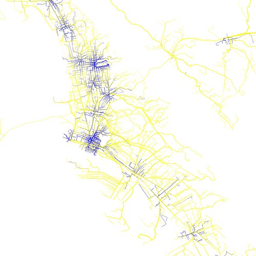
- The blue lines represent where almost all people on their way to BART are walking. Yellow lines show where almost all BART passengers are on bikes, on transit, or in cars.
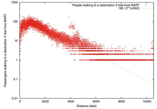
Number of People Who Walk Various Distances from BART
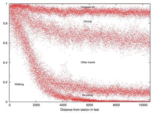
How BART Riders get to the Station, By Distance
BART Pedestrian Origin Outliers
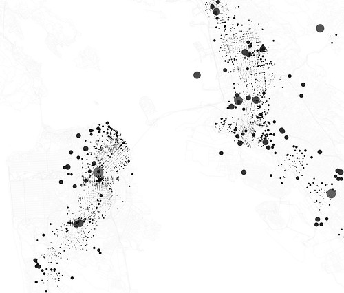
- Dot size is the number of people who walk to BART from there, divided by the overall likelihood of walking that far. The larger gray dots are just so you can see the smaller dots they overlap with
See more interesting transportation maps and pictures on Eric Fischer’s flickr page. And if you’re interested learning more about Fischer’s data maps, check out this interview with him in the SF Gate.
New Commuter Incentive Program

Market Street, San Francisco. Photo credit: torbakhopper
Head’s up!
511CC has a new commuter incentive program page! Learn how you can partake in the Drive Less Commuter Incentive Program and get a cash reward for switching from commuting in a single-occupant motor vehicle to carpooling, transit, bicycling or walking.
Driving less really can help reduce environmental impacts and relieve traffic congestion for all, even if you only ditch the car once a week for your work commute. So if you need an incentive to join the growing number of people saying good-bye to gridlock and leaving the car at home when commuting, be sure to check out the commuter incentive program.
And who knows, it might permanently change your commuting habits once you realize the many things you can get done – like catching up on reading, get exercise, or check email – when not driving. You might even decide to ditch the car for shorter trips too!
Great Race for Clean Air 2012
 It’s back!
The Great Race for Clean Air is a friendly competition between Bay Area companies to encourage the use of commute alternatives such as transit, carpooling, vanpooling, walking and bicycling rather than driving alone to work to reduce greenhouse gases and smog levels in the Bay Area. Last year, 190 companies throughout the Bay Area saved 435 tons of CO2 by using commute alternatives.
Register your company to get started by August 31, 2012. Winning employers will be presented with trophies at a local Board of Supervisors meeting. Every participating employer will receive a certificate for participating. Take a look on how to sign up.
Your employees and co-workers can record their commutes online from September 1 to October 31, 2012. There will be weekly prize drawings for participants who record their commute. See how to log in your commute below.
Let the competition begin! Have fun and good luck!
April 6th is Walk to Work Day 2012!
Get your walking shoes on, Friday April 6th is “Walk to Work Day”!
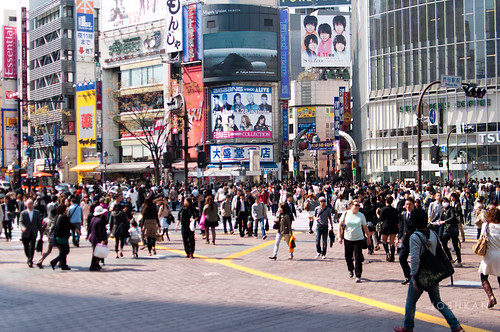
Photo credit: KanKaiEn
The first Friday of April has marked this yearly event since 2004, in attempts to encourage a more active lifestyle in an increasingly sedentary age. The goal is straightforward, and perhaps more easily accomplished in San Francisco, one of that nation’s most walkable cities, than elsewhere.
But what if you’re in a more suburban area, living more than a couple of miles from work but still wish to participate? Try walking over to your nearest transit stop and fill some of the distance gap with BART, AC Transit, or other local transit agencies. Any way to integrate more walking, and less driving, on your way to work on Friday is sure to fulfill the spirit of the day!
And for those who want to have a little social networking fun, and a chance to win a prize, check out this SF Weekly article about how you can connect with Facebook and Twitter today.
From more information about the event, take a look at Walk SF.
Daylight Savings Time Ends November 6: Be safe in the dark
 Daylight Savings Time ends for most of the United States at 1 AM on Sunday November 6.
As we fall back the sun will set earlier in the evening. By by the end of November, the sun will set as early as 4:51 PM. This means a lot of people will be commuting home in the dark. Though fewer miles are driven at night relative to the day, more than half of all traffic deaths occur after dark.
Tips for Bicyclists:
- Use both front and rear bicycle lights. Bicycle lights are required by law, and are a very good idea.
- Be predictable. Don’t make sudden turns without signaling properly. Come to complete stops when required.
- Pedestrians, obey traffic laws, and don’t assume a driver will always see you. Make eye contact before crossing the street.
- Be visible. Do what you can to make yourself and your children more visible using reflective jackets and brightly colored coloring if you’ll be riding after 4:30 PM.
- Parents, suggest bright colors or reflective materials for children when coming home from school.
Be careful out there, and enjoy the extra hour of sleep.
All about Crosswalks
 Crosswalks are those stretches of pavement (and sometimes paint) that make our cities walkable. Did you know:
- Any time a sidewalk ends, whether it is at an intersection or in the middle of a block, the extension of that sidewalk into the street is a legal crosswalk?
- Many legal crosswalks are unmarked, especially in residential neighborhoods?
- A vehicle is required to stop whenever a person is in a crosswalk, marked or unmarked?
- Neighbors often approach the city to paint crosswalks, because a painted crosswalk is more visible to drivers, increasing the safety of people that walk?
Most California marked crosswalks are painted in one of four ways, in order of increasing visibility: two white lines, white lines with a perpendicular “hash marks,” two yellow lines and yellow lines with perpendicular hash marks.
The idea is that the more people use the crosswalk, or the more dangerous the crosswalk is deemed, the crosswalk should be more visible.
There are even more visible kinds of crosswalks, called diagonal crosswalks. Check out this one from Chinatown in Oakland.

Sometimes called “scrambles”, these crosswalks are highly visible because cars don’t always expect them. In an area like Chinatown with a lot of pedestrians, the traffic lights are changed to add an all-pedestrian phase.
The lights go: north-south cars, east-west cars, then people in every direction!
You can see where the name “scramble” comes from, right?
At any intersection, even if you as a pedestrian have the right-of-way (which you do), always look out for cars. Not everyone knows, or respects, the rights of pedestrians. Safety first!
Pedometers. How do they work, anyway?
 Pedometers are a great motivational tool. If you know how many steps you take each day, you can more easily increase your physical activity, which in turn can lower your blood pressure and body mass.
Mechanical pedometers use a mechanical sensor and software to count steps. The most basic pedometers use a mechanical switch to detect steps together with a simple counter. If you shakes it, you can hear a small ball sliding back and forth or a tiny pendulum.
Of course, modern technology opens up lots of cool new ways to design pedometers. Several phones and other personal electronic devices have pedometers built in.
 Some iPhone/iPod/iPad apps to consider include:
Pedometer 24/7 includes a free version!
iTreadmill
Footsteps
Pocket Pedometer
Pedometer
Thoreau on Walking
 Literature aficionados may already be familiar with American author Henry David Thoreau’s other hats: in addition to being an outspoken abolitionist, philosopher, and historian, he was a avid naturalist and lover of the outdoors. Looking at Walden Pond, the subject of Walden, a Life in the Woods, one could understand why Thoreau found such peace and inspiration in nature.
Not only did write of his love for nature. Thoreau also wrote about his favorite means of appreciating nature – walking.
I think that I cannot preserve my health and spirits unless I spend four hours a day at least — and it is commonly more than that — sauntering through the woods and over the hills and fields absoutely free from all wordly engagements. You may safely say a penny for your thoughts, or a thousand pounds. When sometimes I am reminded that the mechanics and shop-keepers stay in their shops not only all the forenoon, but all the afternoon too, sitting with crossed legs, so many of them — as if the legs were made to sit upon, and not to stand or walk upon — I think that they deserve some credit for not having all committed suicide long ago. Continue reading “Thoreau on Walking”
Walkability and Walkscore
 Who doesn’t enjoy a quick stroll? Walking from the library to the drugstore without having to crank up the engine or unlock your bicycle gives you that healthy, productive feeling – plus it’s good exercise!
Of course, being able to walk around requires more than a pair of good shoes – your destinations needs to be reasonably close together, and there needs to be a safe way to get from place to place.
Walkability is a measure of how friendly an area is to walking.
WalkScore.com offers a quick and easy “walkability” score for any address. Using the distances from that location to a horde of amenities – schools, restaurants, cafes, etc. – the site calculates an index of walkability. Test the walkability score of your home or office!
Recently, WalkScore released its list of the ten more walkable cities in the United States. The Bay Area landed two of the ten spots – San Francisco ranked 2nd, and Oakland ranked 10th!
WalkScore also computed the average walkability of the largest cities in California. How did Contra Costa County do?
 Antioch – 49
Brentwood – 45
Danville – 35
El Cerrito – 64
Hercules – 44
Lafayette – 33
Martinez – 49
Oakley – 28
Orinda – 22
Pinole – 47
Pittsburg – 42
Pleasant Hill – 63
Richmond – 53
San Pablo – 56
San Ramon – 32
Walnut Creek – 51
How walkable is your neighborhood? Post your score in the comments or tweet it to us!
Take a walk with the Mayor of Oakley
 Hey residents of Oakley! Want a chance to explore the beautiful Marsh Creek Trail, and have some one-on-one (or several-on-one) time with your mayor?
You’re in luck! Starting this Saturday, July 16, Oakley Mayor Jim Frazier invites you to join him on a three-mile walk. The walk starts at 7:30 am from the parking lot off East Cypress Road behind Kragen’s on the Marsh Creek Trail.
Mayor Frazier invites you, the public, to attend. While you share the scenery, you’re also invited to ask him questions and make suggestions about city business.
For more on the Marsh Creek Trail, check out the East Bay Regional Parks District‘s website. For more on Mayor Frazier, check out the City of Oakley‘s website.
Can’t make it this weekend? This is just your first opportunity to walk with the mayor. These walks will take place on the first and third Saturdays of each month.
Let us know how it goes!
Pedestrians: Rights and Responsibilities
 This morning, standing in a crosswalk, I stood 15 feet from a tractor trailer as it barreled through a red light.
This afternoon, I found this article about plain-clothed cops busting drivers that fail to yield to pedestrians.
These got me thinking: what are a pedestrian’s rights and responsibilities? What are the actual rules (not just what I wanted to shout at the truck driver)? Let’s take a gander at the definitive source for California’s rules of the road, the California Vehicle Code.
California Vehicle Code
Chapter 5. Pedestrians’ Rights and Duties
California’s vehicle code requires that “safe and convenient pedestrian travel and access, whether by foot, wheelchair, walker, or stroller, be provided to the residents of the state”. As they teach you in pedestrian-advocate school, what’s great for a wheelchair also makes life better for an able-bodies pedestrian.
The driver of a vehicle shall yield the right-of-way to a pedestrian crossing the roadway within any marked crosswalk or within any unmarked crosswalk at an intersection.
 What’s an unmarked crosswalk you ask? Let’s say you’re walking down the sidewalk, and the street comes to an intersection. The ten-foot wide piece of road that extends from the sidewalk you’re standing on across the road and to the other side is a legal crosswalk. If the crosswalk is painted, it’s a “marked crosswalk.” If there’s a traffic signal or stop sign, it’s a “controlled intersection.” But whatever the paint or signage, it’s a legal crosswalk, and vehicles are required to yield to pedestrians.
A study by the Berkeley Traffic Safety Center found that 35 percent of drivers surveyed did not believe pedestrians have the right-of-way at marked crosswalks. Just because the law if on your side, look both ways.
(Photo from Atlanta-based Peds.Org)
But if you’re crossing away from a legal crosswalk, yield to drivers, because that’s where they have the right-of-way. Unless there’s street construction or the crosswalk is out of service, in which case pedestrians should walk along the roadway to the left-side, and be careful.
 Whenever any vehicle has stopped at a crosswalk to permit a pedestrian to cross the roadway the driver of any other vehicle approaching from the rear shall not overtake and pass the stopped vehicle.
If you see a car stopped for a pedestrian in a sidewalk, you’re legally obligated to also stop. The pedestrian is less likely to see a second car coming behind a stopped car.
A totally or partially blind pedestrian carrying a predominantly white cane (with or without a red tip), or using a guide dog, the pedestrian has the right-of-way. There are steep fines for using white canes in this way if you aren’t actually blind.
Also, no person may stop a vehicle unnecessarily in a manner that causes the vehicle to block a marked or unmarked crosswalk or sidewalk. Don’t block the sidewalk, either – leave enough room for a person in a wheelchair to comfortably pass.
Be safe out there!
Safe and Sane Use of Highways
Though the times and cars have changed, the danger is the same. Check out this illustration of the damage a car could do to your fragile body at 20, 40, and 60 miles an hour.
The manual “Safe and Sane Use of Highways”, published in 1934, offers a basic introduction to this and other concepts we take for granted today. Windshield wipers, jay-walking, crosswalks – these were relatively new in the 1930s. So was getting hit by a car traveling 60 mph.
Is it enough to make you slow down when you see people walking around?

"Urban Acupuncture" in 2011
 Have you heard the hubbub about San Francisco’s “parklets“?
Parklets are a cute name for a somewhat serious concept. Many downtowns and urban areas have a plethora of public space, but not a whole lot of places to sit, because so much of that public space is paved. Few square inches in the world are more valuable than a sunny spot in downtown at lunchtime on a beautiful day. Imagine taking a 10’x22′ space away from one car, and filling it with space to seat a dozen people. What a transformation!
San Francisco businesses and neighborhoods built eight parklets in 2011, and have received applications for 24 more. Sure Contra Costa County is less dense than San Francisco, but everyone knows their favorite local walkable street and neighborhood cafe.
Can you envision a more walkable Contra Costa County? Make your vision a reality, even if for just a day, on PARKing Day 2011.
Where would you like to see a parklet in September 2011? What areas needs more seating?
The Oldest Form of Transportation: Feet
 Planes, trains, and automobiles are certainly fast modes of transportation, but not everyone flies or takes a train every day. What is the most common form of transportation? So common that almost everyone does it, every day, all over the world, and it doesn’t cost a cent or issue an ounce of greenhouse gas? Walking!
Next in our History of Transportation, we look at shoes. Sneakers, slippers, sandals, boots, boat shoes, and brogues fill our closets and protect our feet, but how did they get there?
The oldest surviving shoes are from 8000 to 7000 BCE and were found in Oregon, but anthropologists date shoes back to 38,000 to 24,000 BCE. Why do they suspect early humans wore shoes? Because the thickness of bones in toes decreased during this period (except for the big toe), suggesting that wearing shoes made for shorter, thinner toes.
The earliest shoes were more foot bags than Prada. Moccasin-type shoes (and their footprints) have been found in modern day Armenia and Iran, and lacked soles – the piece of material between the foot and the ground. Ouch.
 Basic sandals began to appear around 2000 BCE. Mesopotamians, Egyptians, Greeks, Romans, and Etruscans wore simple pieces of leather under their feet that they bound to their ankles with what was most likely rawhide laces. As the Romans conquered Europe (no doubt made easier with shoes), the technology spread. Britons modified the sandals to create something more similar to today’s thongs, with a strap between the first and second toe.
 In the plains of modern China, shoes were made of grass, hemp, and kudzu vine, and were far closer in style to modern shoes than the shoe bags or simple sandals of the western world. People living in the more mountainous terrain of modern China sewed hide boots with hide thread and bone needles.
As the middle class grew in the West, cordwainers became a common profession (cordwainers make shoes, cobblers repair shoes). Shoes expanded up the leg, and boots were born. Buttons, pins, straps, and buckles were drawn into the mix. The wealthy wore shoes that fit with precision, but the poor went without shoes. As such, ridiculously proportioned shoes became the style.
 The components of modern shoes first began to appear in England in 1790, with shoelaces. With cheap and easy shoelaces, buckles began their exit. Shoemakers began to differentiate left and right shoes around 1800. Eyelets for shoelaces were hand sewn until the 1840s, when metal eyelets were mass produced. A rolling machine allowed cordwainers to make more compact leather, making longer-lasting soles, but the invention of the sewing machine in 1846 changed shoe-making forever.
Rubber heels were first patented in the US in 1899, replacing leather heels that wore more quickly. Two well-known shoe companies opened during the rubber revolution and are still around today.
The Converse Rubber Shoe Company was founded in 1908. The company specializes in canvas tennis shoes (designed, literally, for playing tennis), until the Converse All Star is introduced in 1917. Soon, Charles H. “Chuck” Taylor, who would later play with the original Celtics, Buffalo Germans, and Akron Firestones, joined Converse as a salesman and endorses the All Stars. Converse quickly became a symbol of basketball, even customizing shoes for the first all African-American basketball team in 1923. Though bought by Nike in 2003, Converse is definitely still around today.
“Keds” were almost Veds or Peds. The canvas-top sneaker company survives today, but originated as the rubber footwear division of U.S. Rubber. When the company decided to consolidate their 30 brands into a single name, they initially chose “Peds,” from the Latin word for “foot” (also the source of “pedestrian”). Unfortunately, someone else held the trademark, so they picked between the most similar sounding names. Keds won out over Veds, and the brand was announced in 1916. The shoes coined “sneakers” by an advertising agent, because the rubber sole make the shoe much more quiet than the rigid leather shoes of the era. Stride Rite acquired Keds in 1979, but you can still find their canvas-top sneaker today.
 Synthetic cloth and industrial adhesives transformed shoes even further. Standardized sizes allow people to buy and sell shoes all over the world. What’s next for shoes? Only time will tell.
511CC wins Safe Routes to School Mini Grant
 511CC wins Safe Routes to School Mini Grant. The National Center for Safe Routes to School announced today that 511 Contra Costa was one of 25 national applicants to receive a $1000.00 mini grant for Spring 2010. The National Center received 247 Safe Routes to School applications from across 44 states and the District of Columbia.
511 Contra Costa will be working with Dallas Ranch Middle School in Antioch, California to craft a social marketing campaign to educate fellow students about the pedestrian and bicycle safety and health benefits as part of its “Walk and Roll 2 School” program. Selected proposals distinguished themselves through originality of efforts to help lead local community efforts to promote safe walking and bicycling to school.
National Center for Safe Routes to School Press Release
Walk to School Day 2009 is Approaching!

This year’s Walk to School Day, which is organized by the National Center for Safe Routes to School, is coming up soon! October 7 to be precise. You can register for the event here. Walking to school is not only fun, but also great for the environment and your kid’s health. The more people we can get on foot, the safer walkways, crosswalks, and bike paths will become!
Visit the Walk to School USA website for more information about setting up your own walk to school event, ensuring your child’s safety, or customizing your route.
Workshops Scheduled in Contra Costa County This Week For 2009 Bicycle and Pedestrian Plan
 The 2009 Contra Costa Countywide Bike and Pedestrian plan is now available for review on the CCTA website.
There are three community workshops scheduled to discuss the proposed bike plan. Two of the workshops will be held this week on Monday and Thursday. The third and final workshop will be held Monday June 29th.
- The workshops are scheduled at three locations:
- San Pablo: 7 p.m. Monday, Maple Hall, 13831 San Pablo Ave.
- Antioch: 7 p.m. Thursday, Tri-Delta Transit board room, 801 Wilbur Ave.
- Pleasant Hill: 7 p.m. June 29, Contra Costa Transportation Authority, Hookston Square, 3478 Buskirk Avenue, Suite 100.
More information available on the Contra Costa Times website, and the Contra Costa Transportation Authority Website.