The WB Bore #3 of the Caledcott Tunnel will be closed from 10pm to 4:30am on three consecutive nights – Monday, October 23 through Wednesday, October 25 – for scheduled maintenance work. All other bores will remain open.
Tag: caltrans
Caltrans One-way Traffic Control on the Antioch Bridge, March 20-23
Caltrans has scheduled one-way traffic control on the Antioch Bridge (CA-160), due to bridge inspections. One-way traffic control will begin on Monday, March 20 through Thursday, March 23 from 8:00 AM to 2:00 PM each day. During the inspection one side of the bridge will be closed while traffic flows on the other side with one way traffic control assistance. March 20 and 21 Northbound CA-160 will be closed. March 22 and 23 Southbound CA-160 will be closed.
Caldecott Tunnel EB #2 Bore Overnight Closures June 22 at 10pm to June 24 at 4am
The EB Bore #2 of the Caledcott Tunnel will be closed 6/22 and 6/23 from 10 PM to 4 AM each night for scheduled maintenance work. All other bores will remain open.
Caldecott Tunnel EB #2 Bore Overnight Closures May 31 at 10pm through June 3 at 4am
Overnight closures of the eastbound #2 bore of the State Route 24 (SR-24) Caldecott Tunnel will occur Tuesday, May 31 through the morning of Friday, June 3. Closures will start each evening at 10pm and will last until 4am the following morning.
Caldecott Tunnel EB Right Bore Closure May 5 at 10pm through May 6 at 4:30am
Caltrans has scheduled an overnight closure of the eastbound CA-24 Caldecott Tunnel right bore, due to tunnel maintenance work. The closure will take place on Thursday, May 5 from 10:00 PM until 4:30 AM the following morning. During the closure, all other bores in each direction will remain open.
Caldecott Tunnel Bore #1 Closure Overnight 1/12
Caltrans has scheduled an overnight closure of the #1 bore of the Caldecott Tunnel on Wed., Jan.12 at 10pm through Thurs., Jan. 13 at 4:30am. The temporary closure is due to tunnel maintenance.
Help Shape Transportation Projects – Regional & Local Surveys
A simple but effective way to have an impact on transportation projects is by giving your feedback during the planning phase. Get involved and give your input on the Link21 regional transit project (BART, Capitol Corridor), bike and pedestrian accessibility in your area (Caltrans), and projects in Concord, Antioch, San Pablo, and Pleasant Hill.
Click any button below to jump to the related survey page
Regional Survey
Link21 (BART, Capitol Corridor): Link21 will transform Northern California’s passenger rail network into a faster, more connected system, providing safe, efficient, and affordable travel for everyone. At the core of Link21 is a new transbay crossing for BART and Regional Rail. Provide your thoughts on the draft goals and objectives.
This survey is now closed
Local Surveys
Caltrans Active Transportation Plan Survey: Help Caltrans plan for biking and walking improvements in your area. Identify concerns you believe need to be addressed to better walking and biking on and along State Routes near you.

Antioch Safe Streets: The City of Antioch is working to identify potential traffic safety projects. Your input is essential for the development of their Local Roadway Safety Plan. Use the interactive map on the Antioch Safe Streets site to share your concerns regarding traffic and safety.
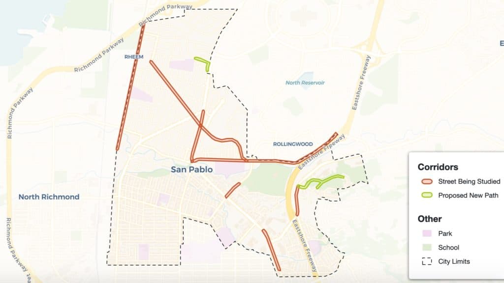
San Pablo Bicycle & Pedestrian Corridor Study: This is a project to make 10 high-priority streets and paths in the City of San Pablo safer and easier for walking and cycling. Survey respondents can enter their name and email for the chance to win a $50 gift card.
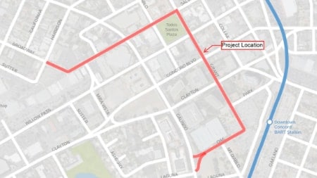
City of Concord Downtown Corridors Bicycle and Pedestrian Improvement Project: Help people get around more easily by bicycle and on foot around Todos Santos Plaza and Concord BART station. The city is looking to update pedestrian curb ramps and pavement striping in those areas and they need your input.
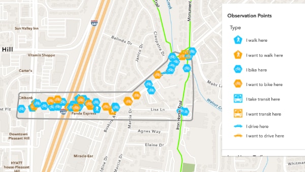
Monument Corridor Study (Pleasant Hill): Help the City of Pleasant Hill improve Monument Blvd. between Contra Costa Blvd. and Mohr Ln. for walking, biking, and transit. Use the interactive map to mark a location you feel needs improvement and describe the issue.
Caltrans District 4 Bike Plan – Take the 2017 Survey!
 Caltrans has set a target to triple bicycling by 2020, but in order to make that happen, they need your help!
The Caltrans District 4 Bicycle Plan, which is currently being created, will guide California’s decision makers in developing bicycle projects and programs. With over 2200 miles of road under their management, Caltrans is relying on local feedback to let them know what residents feel is and isn’t working and what improvements they’d like to see.
 Completing the Bike Plan survey will assist Caltrans with their mission to build bicycle facilities that are safe, comfortable and convenient. These expanded and upgraded facilities will:
- Improve public health and promote active lifestyles
- Create connections that allow people to bike to work, school, or transit, and
- Reduce traffic congestion and greenhouse gas emissions
Caltrans want to hear from as many residents as possible, so please take the survey and help spread the word!
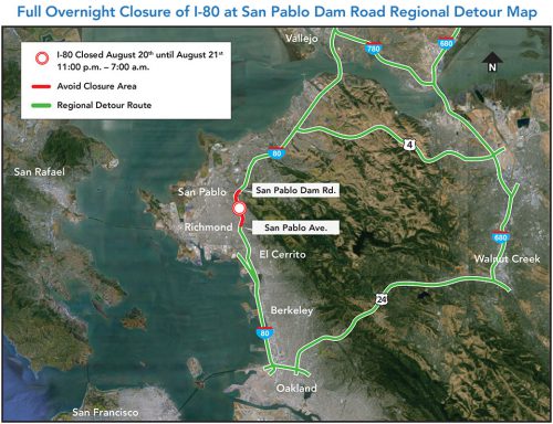
Full Overnight I-80 Closure at San Pablo Dam Rd: Aug. 20-21, 2016
This weekend, Interstate 80 will be closed in both directions between San Pablo Ave and San Pablo Dam Rd for construction work. The closure will start 11pm Saturday, August 20th and end 7am Sunday, August 21st. Temporary detours will be in effect.
For more information, visit: ccta.net/sanpablodamroad
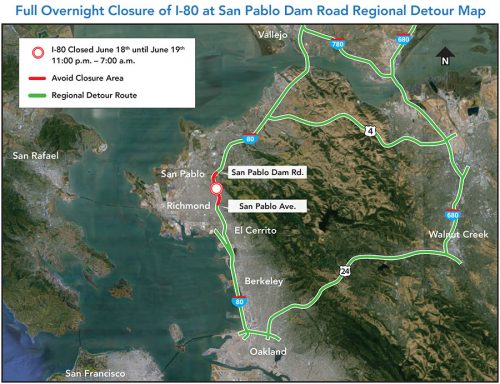
Overnight I-80 Closure June 18, 2016: San Pablo Ave to San Pablo Dam Rd
Overnight on Saturday, June 18, I-80 will be closed in both directions in the Richmond/San Pablo area for construction on the San Pablo Dam Road Interchange. The closure will be between San Pablo Ave and San Pablo Dam Rd and be in effect from 11pm Saturday, June 18 to 7am Sunday, June 19. Temporary detours will be in effect.
For more details on the closure, please visit the San Pablo Dam Road Interchange information page.
I-80/San Pablo Dam Rd Interchange Getting an Upgrade (2016)
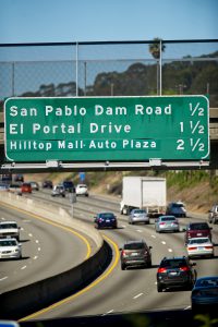 A redesign for the I-80/San Pablo Dam Road interchange is in the works! The project will add roadway capacity, create a safer crossing for pedestrians and bicyclists, and improve the I-80 ramps at El Portal Drive and McBryde Avenue.
The project is a collaboration between the Contra Costa Transportation Authority & City of San Pablo. For more information, click here or watch the video below.
Learn How You Can Help Shape the Future of West County Transportation (2016)
Is getting around West County getting harder? Is traffic on I-80 at every hour of the day getting you down? If you’re interested in providing input to the design of public transportation that works for you, join staff and other citizens at a community workshop to help shape the future of transit in West County.
The West Contra Costa Transportation Advisory Committee (WCCTAC) is hosting a series of community workshops and an online survey to develop realistic public transportation alternatives to driving and commuting on congested roadways. Do you live in Richmond and want an express bus to see your family in Oakland? Do you live in Hercules and want BART to get you into San Francisco on workdays? These are just some of the options being considered, but policy makers need your input to decide which options will move the region one step closer to reality.
If you live, work, or travel anywhere in West County and are interested in expanding your transportation options, WCCTAC wants to hear from you! Attend the workshop closest to you or the one that works best for your schedule (the same information will be provided at each workshop). Attendees will have a chance to win pre-loaded Clipper Cards from 511 Contra Costa!
West County Community Workshops:
Tuesday, April 12
6:30 p.m. to 8:30 p.m.
San Pablo City Council Chambers
13831 San Pablo Avenue, San Pablo
Add to calendar: Google | Outlook | iCal
Wednesday, April 13
6:30 p.m. to 8:30 p.m.
Pinole City Council Chambers
2131 Pear Street, Pinole
Add to calendar: Google | Outlook | iCal
Thursday, April 14
6:30 p.m. to 8:30 p.m.
Richmond City Council Chambers
440 Civic Center Plaza, Richmond
Add to calendar: Google | Outlook | iCal
If you can’t make it to one of the workshops, your option can still be heard. One week before the April meetings, WCCTAC will post a brief survey to learn more about your preferred travel methods and favorite destinations at WestCountyTransitStudy.com. Using your the public’s, WCCTAC will determine which transit options will make it to the next stage. A second round of workshops will be held in the fall to see what the public thinks about the options that were advanced.
California State Rail Plan – Caltrans Wants Your Input (2016)
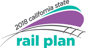 Caltrans is starting work on its 2018 Rail Plan, which will provide a framework for California’s rail network for the next 20 years. The planning process is designed to allow early stakeholder and public input – providing information through meetings and webinars and soliciting feedback via workshops, surveys, emails and online comments.
If you’d like to help shape the Rail plan, you can sign up to the email list, leave a comment on the Comments Page, or send an email to RailPlan@dot.ca.gov. For more ways to participate, visit Caltrans’ Get Involved page.
If you’d like additional information, visit the 2018 California Rail Plan website.
Southbound I-680 Marina Vista Ramp Closure: May 4 – October, 2015 (Martinez)
On May 4, a closure and detour will go into effect for the southbound I-680 Marina Vista/Waterfront Rd off-ramp in Martinez. The closure will remain in effect until October 2015. Between April and October, a seismic retrofit will be performed on the Mococo Overhead Bridge and the I-680 off-ramp will be replaced.
During the closure, southbound I-680 traffic will detour to the Arthur Road interchange, exit and cross under the freeway, return to northbound I-680, and exit at Marina Vista/Waterfront Road. Marina Vista and Waterfront Road will remain open during the extended ramp closure.
Please allow extra travel time when driving through this area and make sure to Slow for the Cone Zone. For more information about the project, visit the Caltrans Mococo Overhead Bridge Project webpage.
NOTE: Post edited to reflect postponement of closure to Monday, May 4.
Overnight/Early Morning Hwy 24 Lane Closures – April 19 & 20, 2015 (Lafayette)
Caltrans has scheduled lane closures along eastbound State Route 24, between Acalanes Road and Oak Hill Road, from Sunday April 19 at 9pm to Monday, April 20 at 8am. This work is in preparation for a slope stability project in that area.
Motorists are advised to expect delays and allow extra time for their commute. Please drive with caution through the construction zone.
![]() For more information about the slope stability construction project, please visit the project webpage.
For more information about the slope stability construction project, please visit the project webpage.
Advisory: I-680 Mococo Overhead Bridge Project Lane & Ramp Closures (Mar. 2015)
 Caltrans District 4 has scheduled the following lane and ramp closures for the Interstate 680 Mococo Overhead Bridge Rehabilitation Project:
On-Ramp Closures
The Marina Vista on-ramp to southbound I-680 will be closed:
- Thursday night, March 26, from 6pm-6am
- 6pm Friday night, March 27 until 12pm Saturday, March 28
Lane/Shoulder Closures at the Marina Vista/Waterfront Road Interchange:
- One northbound lane will be closed from 8pm Friday, March 27 to 5am Monday, March 30
- The left shoulder of southbound I-680 will be closed from 8pm Friday, March 27 through 5am Monday, March 30
Upcoming Closure of Southbound I-680 Off-Ramp to Marina Vista/Waterfront Road
In late April 2015 Caltrans will close the southbound off-ramp from I-680 to Marina Vista/Waterfront Road. The closure will remain in effect for about five months while the contractor removes the old off-ramp structure and builds a new structure.
- Detour: During this closure, southbound I-680 traffic will detour to the Arthur Road interchange, exit and cross under the freeway, return to northbound I-680, and exit at Marina Vista/Waterfront Road
- Marina Vista and Waterfront Road will remain open during the extended ramp closure
![]() Please drive cautiously through the construction zone, follow the directions of flaggers, leave a safe traveling distance between your vehicle and the vehicle ahead of you, and Slow for the Cone Zone. The California Highway Patrol will be on site during these closures.
Please drive cautiously through the construction zone, follow the directions of flaggers, leave a safe traveling distance between your vehicle and the vehicle ahead of you, and Slow for the Cone Zone. The California Highway Patrol will be on site during these closures.
For more information about the project visit the Caltrans I-680 Mococo Bridge Rehabilitation Project page.
Antioch Bridge Lane Closures (Mar. 2015)
Caltrans is reminding motorists that one-way traffic controls will be in effect on the Highway 160 Antioch Bridge as crews perform routine inspections of the span this week and next week. Crews will alternate lane closures in both northbound and southbound directions, with flaggers and a pilot car helping direct traffic. The work is slated from 9 a.m. to 2 p.m. on four consecutive weekdays – Monday through Thursday of this week and March 16 to 19 next week. This will allow one traffic lane on the bridge to remain open during the inspections. Motorists should expect delays and allow for extra travel time. Work is dependent on the weather. Vessels will pass normally beneath the bridge on the San Joaquin River.
Overnight Highway 4 Closure (Antioch): February 25-27, 2015
The California Department of Transportation and the Contra Costa Transportation Authority are constructing two new connector ramps, one connecting westbound State Route 4 (SR-4) to northbound SR-160, and one connecting southbound State Route 160 (SR-160) to eastbound SR-4 in Contra Costa County.
Part of this construction work entails adjustment of temporary bridge supports that span over SR-4. In order to ensure crew and public safety during this work, the contractor will close all lanes of SR-4 in the eastbound and westbound directions between the SR-4/SR-160 connector ramp and Laurel Road.
These closures are scheduled to take place on the evenings of February 25, 26, and 27th from 11:59pm to 5:00 am.
The detour for this work will be as follows:
- Eastbound motorist will be directed off the highway at the SR-160 off-ramp and redirected to return to eastbound SR-4 via the Laurel Road on-ramp.
- Westbound motorist will be directed off the highway at Laurel Road on-ramp and redirected to westbound SR-4 via the entrance of southbound SR-160.
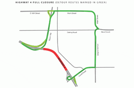
Motorists are advised to expect delays and allow extra time for their commute. Please drive with caution through the detours and leave safe traveling distance between your vehicle and the vehicle ahead of you.
I-80 Closure WB at Carlson Blvd in Richmond (Aug. 2014)
8/6/14 – CONSTRUCTION HAS BEEN RESCHEDULED FOR A LATER DATE.
TRAFFIC ADVISORY – Nighttime Closures on Westbound I-80 to Begin in Early August – Plan for Detours
Caltrans will soon install the first in a series of eleven approximately 25-foot-high overhead sign frames that will span the width of the westbound I-80 lanes. In the coming months, the sign frames will be installed between Cutting Boulevard in Richmond and Powell Street in Emeryville, necessitating lane and full westbound freeway closures in the vicinity of the installations.
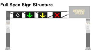
Travelers are advised of nighttime lane closures and full westbound closures beginning August 7, 2014. Motorists are advised to expect detours and delays during the nighttime closures.
Beginning Tuesday, August 5: To facilitate sign frame installation, portions of westbound I-80 will be closed from 1 a.m. to 3 a.m. on Tuesdays and Thursdays. The first installation will occur at Carlson Boulevard in Richmond. During this time, westbound lanes will be closed to traffic in the vicinity of the installation, and motorists will be detoured to a local frontage road. Eastbound and westbound lane closures of I-80 will continue on Sundays through Thursdays, beginning at 9 p.m. and ending at 5 a.m.
Every Tuesday and Thursday Continuing Until October:
Caltrans will continue to implement closures on Tuesdays and Thursdays between 9 p.m. the previous evening – 5 a.m. (lane closures) and 1 a.m. – 3 a.m. (full closures) on portions of westbound I-80 until all eleven sign frames have been installed. The second closure and sign frame installation will occur at Cutting Boulevard in Richmond.
Caltrans anticipates that the closures will continue through October 2014. However, this work is weather-dependent, and the schedule is subject to change.
Roadway work entails installing large overhead sign frames that will feature new electronic signage. The signage will be activated in early 2015 as part of a larger network of I-80 SMART Corridor strategies to ease traffic congestion and enhance safety on this heavily travelled corridor between the Bay Bridge Toll Plaza in Alameda County and the Carquinez Bridge in Contra Costa County.
Read the full press release
![]()
Caltrans Report: Walking, Biking, Transit on the Rise (2014)
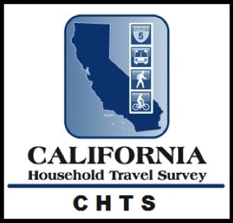
In March, Caltrans released the results from its latest California Household Travel Survey (CHTS), which looks at how we in California travel. The primary finding echoes what many suspect– Californians are driving less. The percentage of California residents walking, biking, or using public transportation more than doubled since 2000; the three modes increased in mode-share, collectively, from 11 percent to 23 percent.
Caltrans Director Malcolm Dougherty notes of the survey’s findings, “Based on this research, we can make good decisions about transportation that will improve mobility, air quality, and travel choices for all Californians and make our state a better place to live and work.”
The table below from the recent CHTS shows the exact breakdown of travel mode distribution, and how it compares to the 2000 survey:
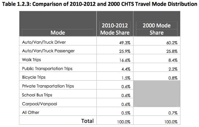 Single-occupancy cars remain the most prevalent travel mode. However it now makes up less than half of all trips, having plummeted from 60.2% to 49.3% of trips.
Interestingly, despite frequently hearing about today’s public transit and bicycling booms, the fastest growing travel mode in the Golden State over the last decade was walking, which more than doubled from 8.4% of trips to 16.6% trips. This is not to say that reports of increased levels of public transit use and bicycling are misleading, in fact the two modes doubled their respective mode-share since Caltrans’ 2000 CHTS.
The results from the survey mark a dramatic shift in the state’s travel patterns and show no signs of reversing. Looking at the numbers one can’t help but to wonder– what will the next California Household Travel Survey look like?
Active Transportation to Get $360 Million (2014)
Caltrans, regional transportation agencies and the federal government have combined funds to provide $360 million in grants for the Active Transportation Program (ATP). Active Transportation is a term used to describe walking, biking, and transit. The funds for ATP will be targeted at projects like bike lanes, safer intersections for pedestrians, safety improvements leading to and around transit stops, and non-infrastructure programs like Safe Routes To School safety education outreach.
Jeanie Ward-Waller is the California advocacy organizer for the Safe Routes to School National Partnership. She said this is the most money by far that has been offered to improve walk/bike routes. But she said that it is also unique because the priorities for awarding the money are not just about transportation. Part of the decision about awarding the money will be based on potential boosts to public health. Some money is earmarked for projects in disadvantaged communities. “It’s watershed in terms of supporting walking and biking, but it’s also a watershed in how it is being targeted,” Ward-Waller said. “I think it’s a new standard about how we are approaching transportation and prioritizing things like public health and sustainability and making sure equity is a lens.” Read the full article in California Report.

Lane #1 of SR-160 in Antioch to Be Closed Temporarily (Apr. 2014)
Caltrans will close Lane #1 of SR-160 in Antioch, in the northbound direction between SR-4 and the 18th Street/Main Street off-ramp on Thursday evening, April 24, from 6:00 pm to 6:00 am. Calrtrans and the Contra Costa Transportation Authority (CCTA) are constructing two new connector ramps, one connecting westbound Highway 4 to northbound SR-160, and one connecting southbound SR-160 to eastbound Highway 4 as part of the Highway 4 improvements.
The Highway 4 projects include improvements that will help revitalize eastern Contra Costa County. The projects expand Highway 4 from four to eight lanes between Loveridge Road and SR-160, add two connector ramps between Highway 4 and Highway 160, and add a BART extension from Pittsburg to Antioch (eBART). This will greatly improve transit accessibility for the region and help reduce traffic congestion and enhance the quality of life for the more than 250,000 residents of eastern Contra Costa County. The projects have been carefully staged to keep 130,000 vehicles per day moving as major construction and demolition work continue, and include over *$1.3 billion in State, Federal, Contra Costa Measure C & J sales tax, regional bridge tolls, and other local funds.
Contra Costa HOV Lanes on I-680 to Be Converted to Express Lanes (2014)
The Bay Area Infrastructure Financing Authority (BAIFA) is working closely with Caltrans to convert the existing HOV lanes on I-680 into express lanes from Rudgear Road to Alcosta Blvd. in the southbound direction and from Alcosta Blvd. to Livorna Road in the northbound direction. Like existing HOV lanes, express lanes are FREE for carpools, vanpools, buses and other eligible vehicles while allowing solo drivers to use the lanes for a toll.
Open House
BAIFA invites everyone to attend an informational meeting to learn more. Project plans will be on display and project team members will be present to provide input about the project.
Thursday, January 30, 2014
5:30 – 7:30 p.m.
San Ramon Community Center at Central Park
12501 Alcosta Blvd. San Ramon, CA 94583
OnLine Public Open House
Can’t make the meeting in person? BAIFA is also hosting an online public meeting at www.BAIFAexpresslanes.org that will begin January 30 and be open for two weeks, closing February 13. The online format will allow the public to view the same information that will be shown at the public meeting and provide input during the two-week period. Once on the project website, click the link to view the information.
Visit www.BAIFAexpresslanes.org or contact MTC Public Information at (510) 817-5757 for more information.
Caltrans, Amtrak Announce New Bike Reservation Policy to Improve Customer Service and Enhance Safety (2013)

Bike aboard Amtrak. Photo credit: ubrayj02
Looking to take a nice train and bike trip along the coast this summer?
The Source published this news release from Caltrans, which funds some passenger rail service in California, regarding the new bike reservation policy (with our emphasis added) :
Caltrans, Amtrak Announce New Bike Reservation Policy to Improve Customer Service and Enhance Safety
SACRAMENTO – Amtrak California passengers traveling with bicycles can reserve onboard bike rack space free of charge beginning June 1, 2013 when booking travel on Pacific Surfliner trains.
“We heard our customers and we responded,” said Caltrans Director Malcolm Dougherty. “Caltrans eliminated the $5 bike reservation fee to make it as easy as possible to bring your bike along when riding the Pacific Surfliner trains.”
Previously, without a bike reservation system in place, when bike racks became full, passengers had no choice but to store bikes next to luggage storage areas or walkways. At times, if bike traffic became too heavy, bike passengers would not be allowed to board at all.
“With bike reservations, planning travel is made easier by enabling bike-toting passengers to choose an alternate train should their first choice be fully booked. It’s truly a win-win,” said Caltrans Division of Rail Chief Bill Bronte.
While there is no cost to reserve a bike slot, reservations will be required for each travel segment and must accompany a valid Amtrak ticket. Bike reservations can be made one of several ways: Online when booking tickets at AmtrakCalifornia.com (click “Add Bike to Trip” after selecting the departure and class of service); at Quik-Trak kiosks (visit the Amtrak California Station Directory for kiosk locations); from station ticket agents; or by calling 1-800-USA-RAIL.
Amtrak Multi-Ride Ticket holders (10-trip or Monthly Pass) can only obtain bike reservations through station ticket agents or by calling 1-800-USA-RAIL. Amtrak has issued refunds to passengers who booked and paid for bike reservations in advance.
Most trains can accommodate six bikes. Passengers should reserve space as early as possible, as bike space is limited and may not be available on all trains or departures. All bike passengers are responsible for securing their own bicycles in provided bike racks.
About Amtrak California: Under the Amtrak California banner, Caltrans funds three of the five busiest intercity passenger rail routes in the Amtrak system: the Pacific Surfliner(r) corridor (ranked second), the Capitol Corridor(r) (ranked third), and the San Joaquin(r) corridor (ranked fifth). Caltrans manages both the Pacific Surfliner and San Joaquin corridors. The Capitol Corridor, although funded by Caltrans, is managed by the Capital Corridor Joint Powers Authority. Visit us at www.amtrakcalifornia.com; join us on Facebook at Facebook.com/AmtrakCalifornia or follow us on Twitter at Twitter.com/Amtrak_CA.
Note: Folding bicycles may be brought aboard certain passenger cars as carry-on baggage. Only true folding bicycles (bicycles specifically designed to fold up into a compact assembly) are acceptable. Generally, these bikes have frame latches allowing the frame to be collapsed, and small wheels. Regular bikes of any size, with or without wheels, are not considered folding bikes, and may not be stored as folding bikes aboard trains.
You must fold up your folding bicycle before boarding the train. You may store the bike only in luggage storage areas at the end of the car (or, in Superliners, on the lower level). You may not store bikes in overhead racks.